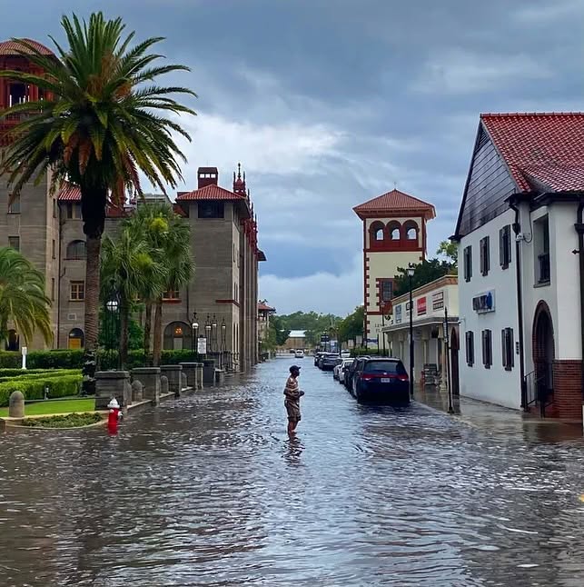
No hurricane. No tropical storm. Not even a named system anywhere near us. And today, the streets along the east coast of Florida are under water anyway.
In St. Augustine, king tides turned residential streets into waterways, and floodwater delayed city services and trash pickup. Along Avenida Menendez, high tides and rough water are hitting the seawall, right as the new seawall project gets underway.
Down at Port Canaveral, the tide gauge hit 3.02 feet above mean higher high water yesterday morning, the highest water there from anything but a tropical system since the gauge went in back in 1994. This ranks among the top five flood events at Port Canaveral, and the coastal flood warning runs all the way to Friday morning.
Here is what is doing it, and it is three things at once. The Hunter’s Moon went full just after midnight early Monday morning, the moon reaches perigee, its closest point to Earth, on Wednesday, and a northeast wind has been stacking water against the coast for days, squeezed between low pressure over the Bahamas and high pressure over the Mid-Atlantic.
And here is the part that should get your attention. This king tide is actually slightly less intense than average, because the full moon and perigee are a couple of days apart. And it is still a top five flood at Port Canaveral. That is what happens when the sea itself is nearly a foot higher than it was in 1950, and still rising about three inches a decade. The tide did not get that much bigger. The ocean it rides on did. It does not take a hurricane anymore. A king tide and a breeze will do it.
That is why coastal resilience is a must for our coastal communities, and especially here on the West Coast of Florida. That is the question we will be answering on November 12 at Selby Auditorium, how do you build a coast to protect Sarasota from flooding and storm surge in an age where a direct hit by a hurricane is no longer needed for severe flooding?
So tell me, what should coastal Florida be building for first: the next hurricane, or the next high tide?
Tickets for the November 12 conference, From Climate Risk to Climate Resilience, Selby Auditorium, Sarasota: https://tinyurl.com/2aplfprg
Bob Bunting, CEO, Climate Adaptation Center