Our First Hurricane Forecast for 2021 – it’s time to get ready!
The CAC in Sarasota, Florida is issuing our first Hurricane Forecast for 2021.
Before getting to this year’s outlook, a brief review of the record 2020 hurricane season is in order.
2020 – a Year to Remember
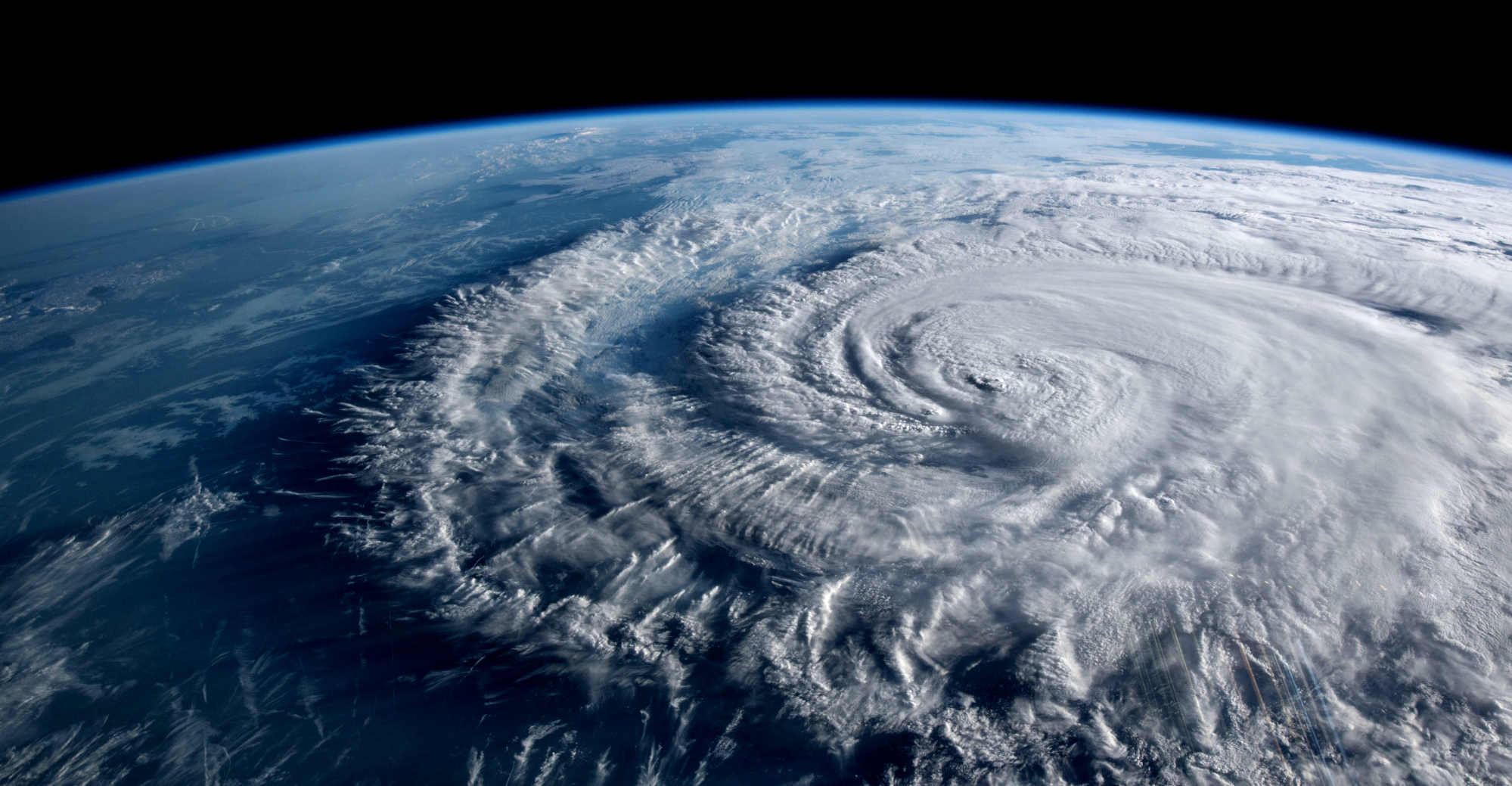
Last year 30 tropical storms lit up the tropics and made 2020 the year with the most tropical storms in recorded history. For the 5th year in a row there was a Category 5 Hurricane, Iota. A spectacular Sentinel-2 satellite image of Iota’s pinhole eye is shown below.
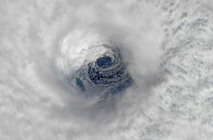
Image: Pierre Markuse
There were also three Category 4s. Both Laura and Eta were Category 4 storms during their life cycle, with Laura striking the Gulf coast with 150 mph winds and Eta downgraded to a Category 1 storm as it passed just off the west coast of Florida before moving inland. Nevertheless, Eta caused historic flooding on Florida’s Longboat Key.
In total, 12 tropical storms made landfall in the U.S., with one hitting southeast Canada with rare hurricane force winds. There were 13 hurricanes, more than twice the normal yearly total.
Had it not been for early season thick Sahara dust blown to North America from the expanding Sahara Desert, the season could have been even worse. Dust acts as a reflector of solar radiation and results in slightly cooler sea surface temperatures (SSTs), thereby keeping tropical storms weaker than they would have been without the dust. The dust is also suspended in air that is very dry and that also inhibits tropical storm development.
A record ten storms went though explosive development cycles. These systems were able to spin up in record time making the 2020 hurricanes much more dangerous than normal!
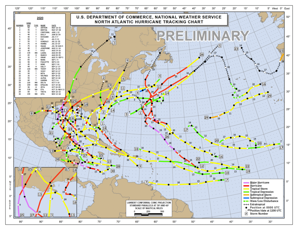
The spaghetti tracks of all 2020 storms are shown below.
Factors Impacting Hurricane Development for 2021
There are three factors I look at to gauge hurricane development for a particular season.
Sea Surface Temperatures (SSTs) in the Atlantic and the Caribbean – Warmer than normal SSTs serve as rocket fuel for tropical storm formation and hurricane development.
The presence of either La Niña or El Niño in the Pacific – When SSTs in the North Pacific are below normal (a La Niña event), the jet stream moves north and weakens, and wind shear in the Gulf of Mexico and Atlantic is usually less than normal. Low wind shear allows hurricanes to more easily grow and maintain their circulation pattern.
The amount and frequency of Sahara Dust outbreaks – The Saharan dust is embedded in dry desert air and dry air entrained into a tropical storm keeps it from expanding and intensifying. SSTs under dust clouds tend to be cooler too, which also impedes hurricane development.
Normally there are 12 tropical storms in an average year, 6 of them become hurricanes and 3 become major hurricanes (Category 3, 4 or 5.)
Early Indications are for a Very Active 2021 Hurricane Season
SSTs are well above normal over the Gulf of Mexico and Atlantic, while SSTs in the Caribbean are near normal.
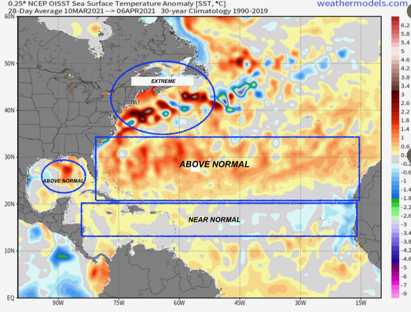
Sea Surface Temperatures are warmer than usual, favorable conditions for hurricanes. Data from NOAA National Centers for Enivronmental Prediction. Chart source: weathermodels.com. Annotations by CAC.
Notice the above normal and extremely warm areas off the NE coast of America, in the Gulf of Mexico where the Loop Current is strong and warm and in a large swatch of the Atlantic between 20° and 40° N. The tropical Atlantic is near normal.
The oscillating El Niño/La Niña pattern is now in its La Niña phase. The models forecasting these phenomena are predicting either weak La Niña or neutral conditions during peak hurricane season from August though October.
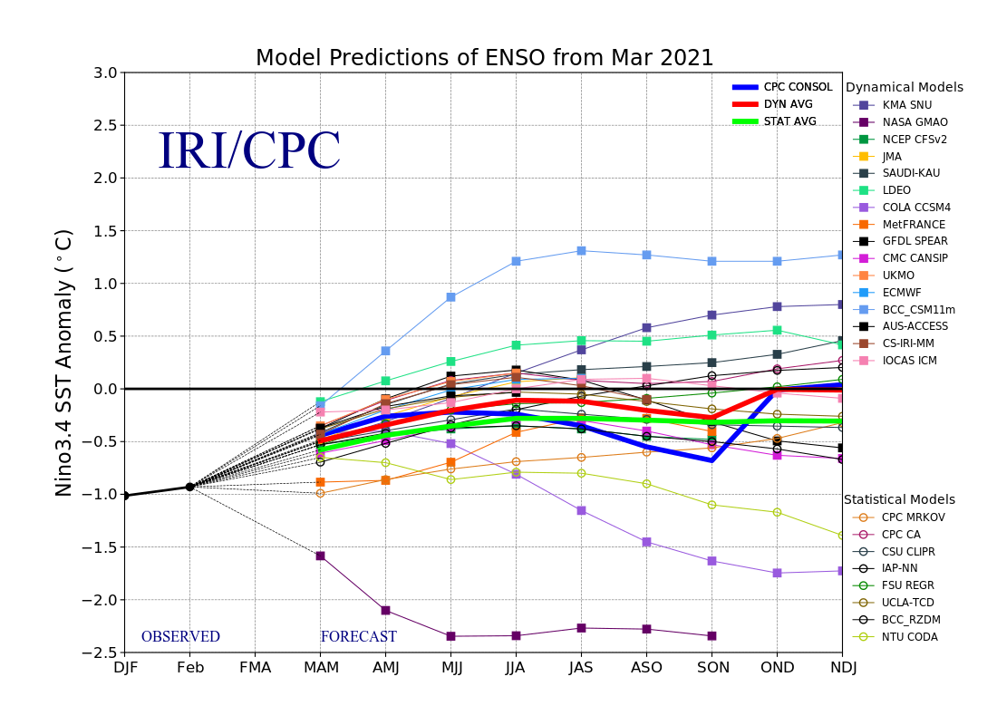
El Nino Southern Oscillation forecast for 2021. Graph: International Research Institute for Climate and Society, Columbia University
The result is that wind shear in the Atlantic and in the Gulf of Mexico will likely be lower than normal. When this happens, hurricanes are usually more frequent and more intense.
Finally, Sahara Dust, in my view, will be less significant in the overall hurricane season this year. Last year was a very active dust season and another as intense is not likely.
With all factors positive for hurricanes formation in 2021, let’s move on to the early forecast. By the way, this forecast will be updated twice. Once on June 15th and again on August 15th in order to provide the best possible outlooks as the season develops.
2021 CAC Hurricane Forecast
The CAC is predicting a very active season with 20 named storms.
Of the 20 storms, 10 should be hurricanes.
Five Major Hurricanes, Category 3-5 are forecast. Three are normal.
Because the waters are so warm in the Gulf and along the entire Atlantic seaboard the probability of a hurricane striking the US coastlines are higher than average. This is true for both the east and the west coast of Florida including the Florida panhandle.
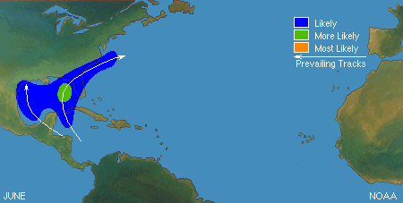
National Hurricane Center storm track predictions for June 2021
A storm moving up the east coast will find favorable water temperatures all the way to Canada! There is no escaping hurricanes in a climate warmed world!
Because of the high temperature Loop Current in the Gulf an early season hurricane impacting the west coast of Florida cannot be ruled out. Climatologically early season storms form in the Yucatan area and move into the eastern Gulf.
The greatest threat for Florida’s west coast will come in October when the worst storms often form and the climatology favors hits from storms forming in the Yucatan area. This doesn’t mean a hurricane force storm will not visit Florida earlier.
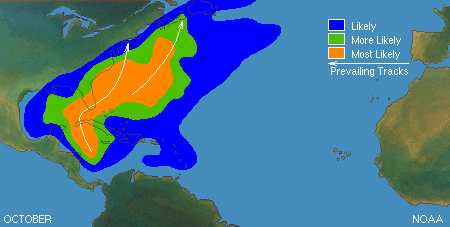
National Hurricane Center storm track predictions for October 2021
With hurricanes becoming more erratic due to slower jet stream steering currents aloft caused by differential warming that is twice as high in the arctic as it is in the tropics, hurricanes can stall for long periods and move in ways we are not used to seeing.
Sarasota’s Sunshine Coast has avoided many storms because of the way Florida tilts from NW to SE. That tilt usually means the Florida Panhandle gets storms that we miss. It may not be so true this year and in future years!
Summing up this hurricane season forecast by the CAC, expect an active year with a higher than normal chance for our area experiencing hurricanes and tropical storms. Given the favorable conditions setting up the hurricane season, now is the time to prepare and think though your own hurricane plan.
Where will you go? What will you need? Now is the time to get prepared!