As hurricane season approaches, the Climate Adaptation Center (CAC) has released its much-anticipated 2026 Hurricane Season Forecast. Building on years of accurate forecasting, the CAC’s predictions and expert advice can make the difference between vulnerability and preparedness. This year’s outlook provides valuable insights into storm trends, key contributing factors, and unveils the CAC Sarasota Living Laboratory as the next step for climate resilience on Sarasota Bay
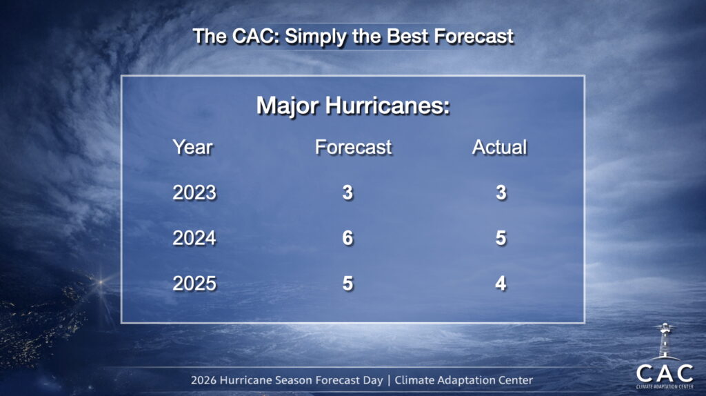
We are proud that over the past three hurricanes seasons, the early CAC Hurricane Season Forecast has been SPOT ON predicting Major Hurricanes! Over the past three season combined, the CAC has missed the number of Major Hurricanes by just 2. We forecast a total of 14 Major Storms and there were 12. No other forecast has been better!
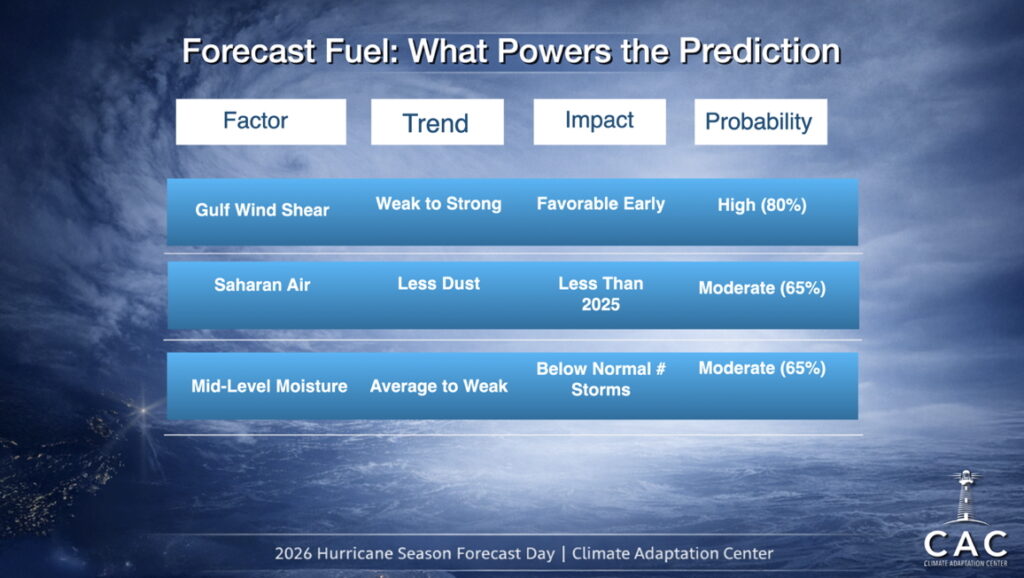
Here are our recipe ingredients list or the factors that will guide this year’s forecast.
Forecast Fuel: The Ingredients of Hurricane Formation
Hurricanes thrive under specific conditions, and the following factors will significantly shape the 2025 season:
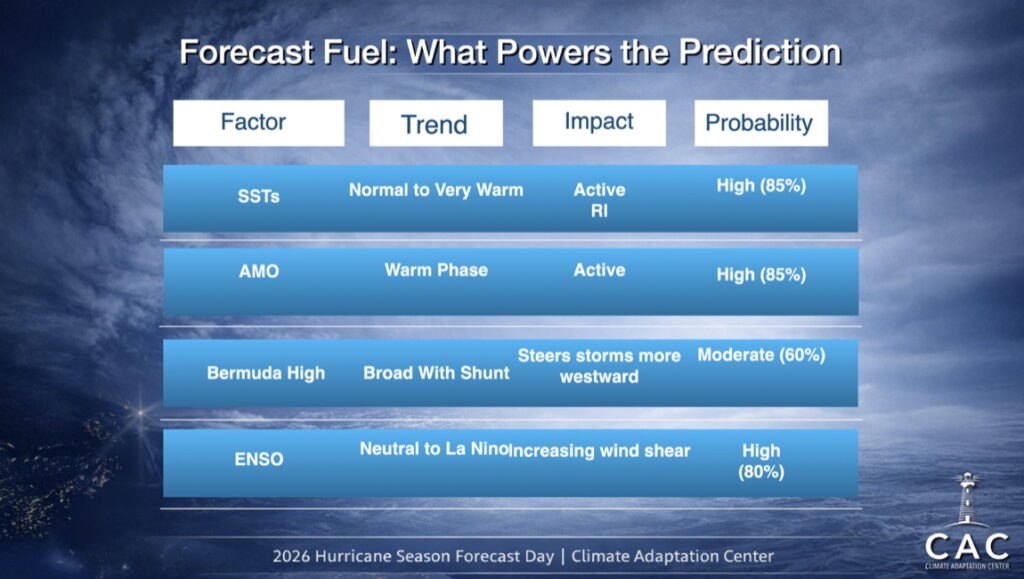
1-Sea Surface Temperatures (SSTs): Warmer-than-average SSTs provide more energy for storm formation and intensification. Current data indicates that SST anomalies—particularly in the Gulf of Mexico and Caribbean Sea—are expected to be very warm, enhancing the likelihood of active rapid intensification (RI) should a storm traverse the Gulf this year. The Main Development Region MDR which includes the Atlantic, Caribbean Sea and Gulf is normal overall.
Because The Gulf is again warmer than normal, when storms RI near a coastline, they can go through RI strike with devastating impacts that leave little time to fully prepare.
Let’s look at 3 different but complimentary views of water temperatures.
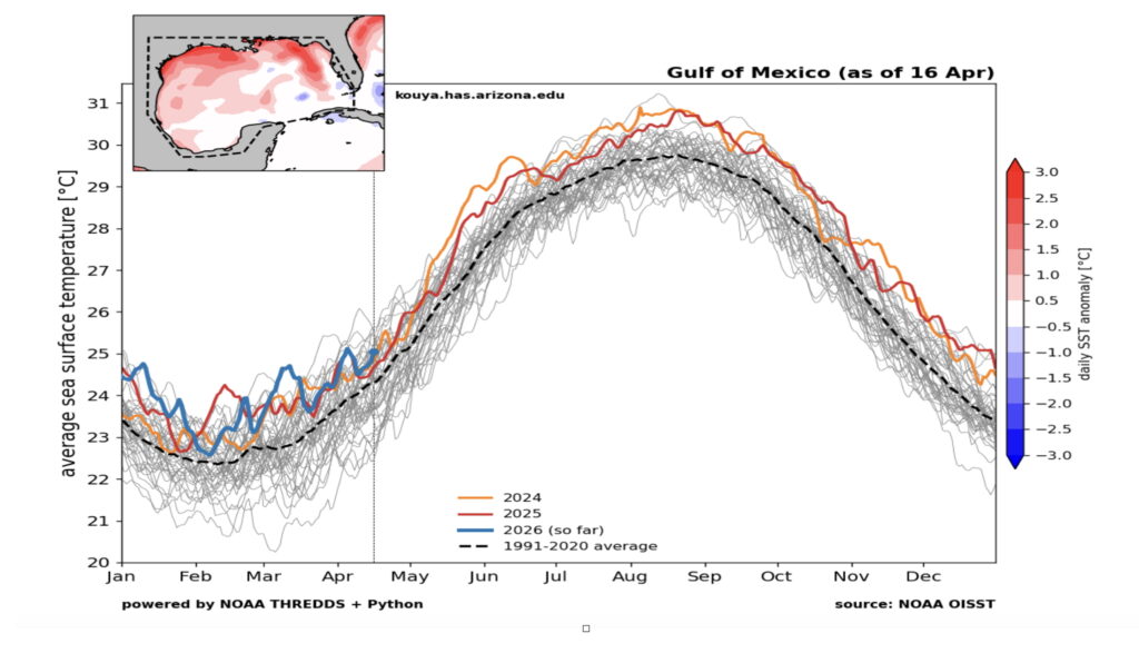
While the SSTs are slightly cooler in the MDR overall than last year at this time, they are still quite elevated and are quite warm in the Gulf.
The Loop Current is shown clearly in the Gulf. The Loop Current provides extra warm water to developing hurricanes. In the image below, one can easily see the Loop current in the SE Gulf.
Next, is Ocean Heat Content (OHC) – when temperatures of the sea are warm down several hundred feet, that pool of warm water acts a ‘Rocket Fuel” for hurricanes especially in the absence of wind shear.
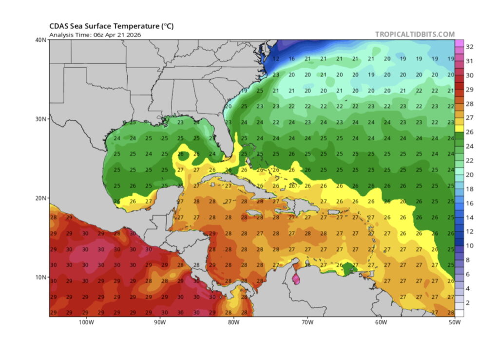
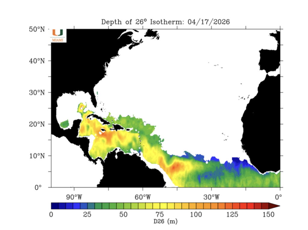 The 26°C water temperatures, the magic number for hurricane formation, is not only present on the sea surface but is already quite deep into the sea. In fact, the red areas show where warm water is 300 feet deep. As spring turns into summer, expect this deep warm water area to expand.
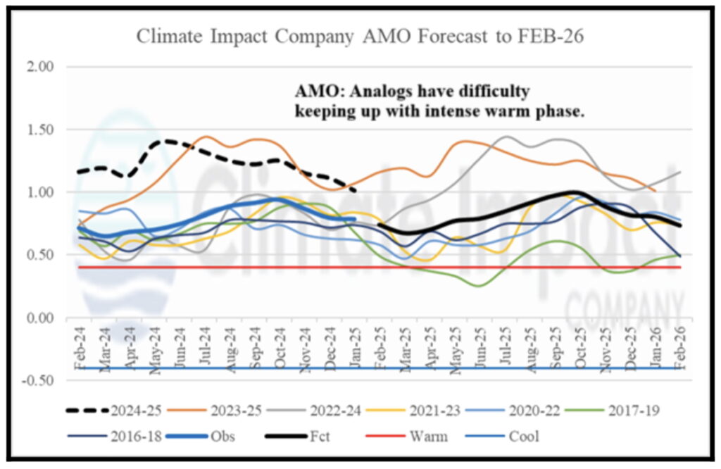
2-Atlantic Multi-Decadal Oscillation (AMO): The AMO is the variability of the SST over decades. Over that time frame it has a cool phase and warm phase. For 2026 the AMO remains in a warm phase, which historically correlates with higher hurricane activity. This year, this pattern continues to be conducive for tropical cyclone development.
In fact, looking at the dashed line in the image below, one can see how the actual warming is higher than most models and analogue years can now predict. In other words, the models are for the most part, under forecasting the strength of the AMO. The red horizontal line shows the delineation between warm phase and cool phases.
The takeaway is the Atlantic remains in a very warm phase which is a positive factor for storm development.
3-Bermuda-Azores High: A weaker Bermuda High typically steers storms northward earlier in their path, which may shift storm trajectories and decrease direct impacts on the southern U.S. coast. In 2025 the position of this High-Pressure System was over the Azores and kept the 4 major hurricanes of 2025 away from the Gulf by shunting them to recurve off the US Atlantic coastline.
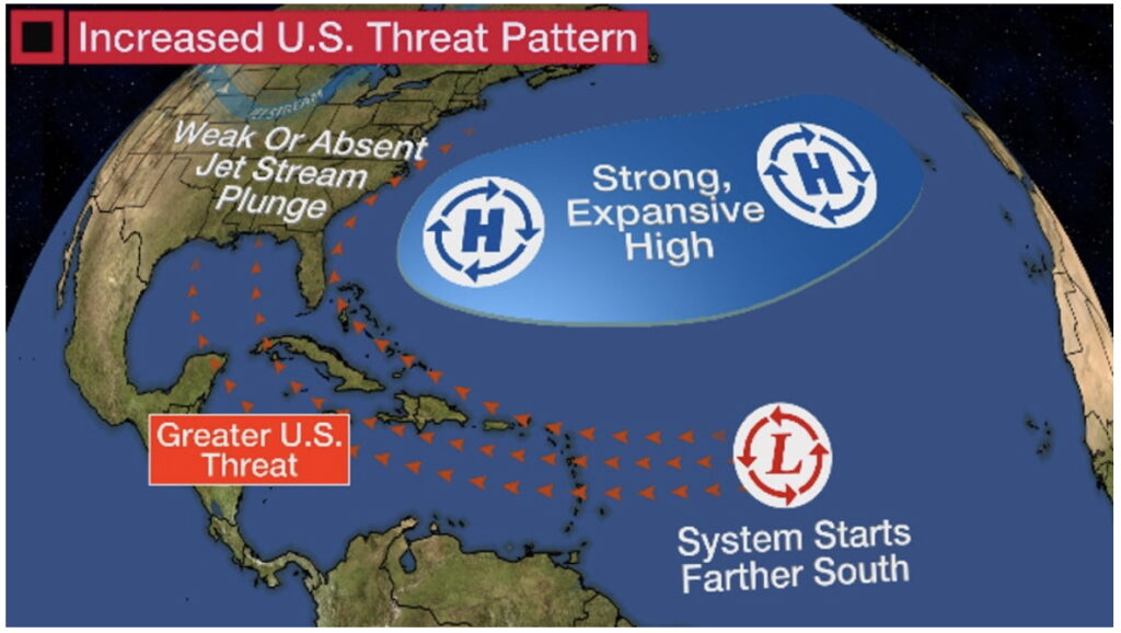
In 2026, indications are that the High will have two centers. That means that some of the storms will move more westward toward the Gulf.
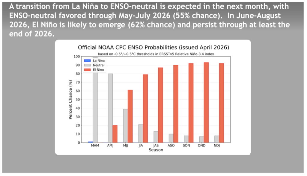
4-El Niño Southern Oscillation (ENSO): The ENSO condition is has evolved from a La Nina condition, favorable to hurricane formation to Neutral conditions now. But an El Nino, perhaps a strong one, should be developing over the next 3 to 6 months. The timing of this El Nino event will shape the coming storm season.
AND
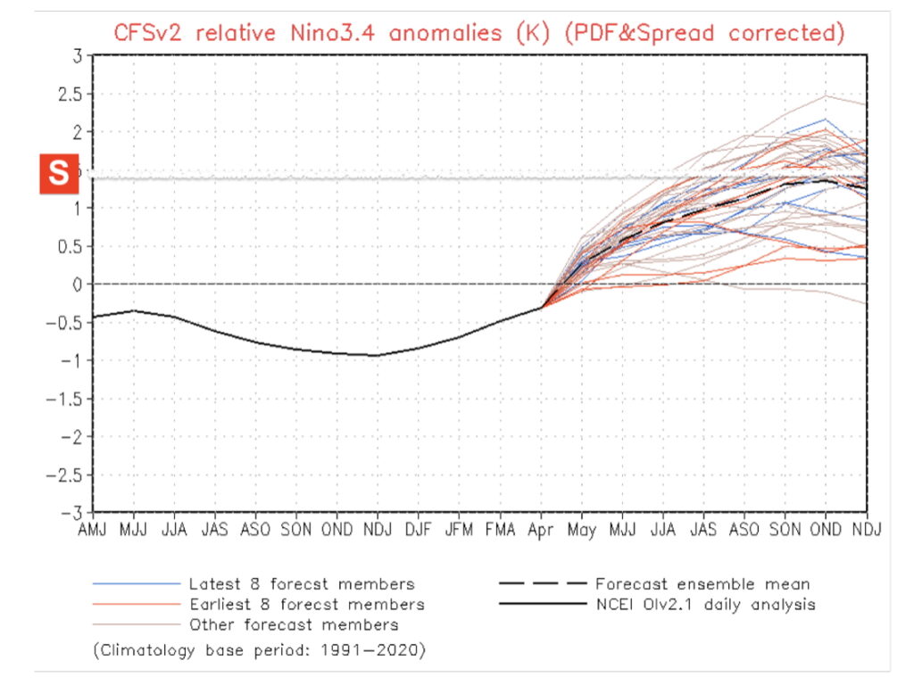
The graphics above shows the present SST in the ENSO critical area. One can easily see the Pacific is warming and all the spaghetti modes show major warming though hurricane season. The red S on the left-hand ordinate is the demarcation line for a Super El Nino. Some models are forcing a Super El Nino during peak hurricane season.
In any event the occurrence of an El Nino is highly correlated to increased Wind Shear and fewer storms.
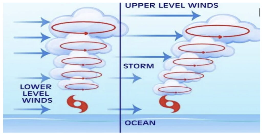
5-Wind Shear: Because El Nino conditions are likely, wind shear is predicted, creating a unfavorable environment for storm development.
To review wind shear. When the winds increase with height from the same or different directions, it tends to blow the center axis of a storm downwind. The most efficient environment for hurricanes is low wind shear because the center of the storm can build up vertically which makes it an efficient energy conversation machine increasing the spin around the eye.
Think of an ice skater spinning. At first the spinner is doing so slowly. But as the skater brings in their arms to the center and stands up straight the spin increases. It’s the same think with storms. We call it the conservation of angular momentum.
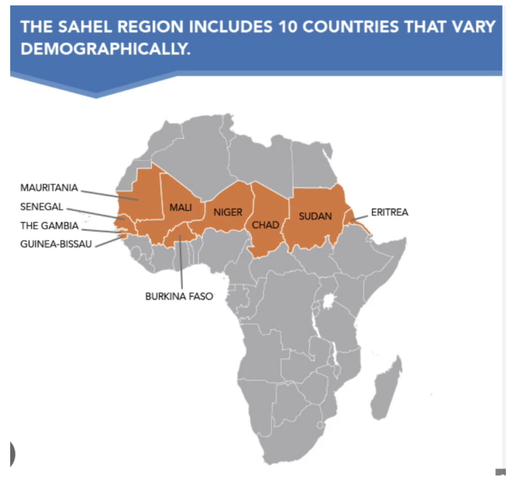
6-Mid-level Moisture: is an important parameter too. The story starts with African Easterly Waves that move across the Sahel.
When the area in orange is wet two things happen. The dust cloud from winds blowing across this semi-arid region is suppressed. When dust is limited, hurricanes have more mid-level moisture to help them grow.
The forecast from our national climate model shows a large green and blue area showing excessive rainfall in August 2026.
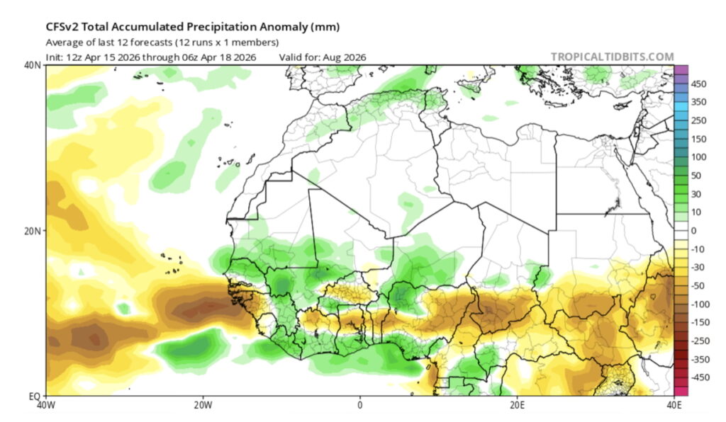
If accurate, dust will be suppressed, and more moisture will be available to the easterly wave storm systems emerging into the Atlantic which would aid hurricane development as peak hurricane season begins.
Looking at the big picture for the Main Development Region for hurricanes, there appears to be large swaths of heavy rainfall suggesting lots of moisture availability especially for June.
With this pattern and an emerging but not yet established El Nino, June is a month of concern for the West Coast of Florida.
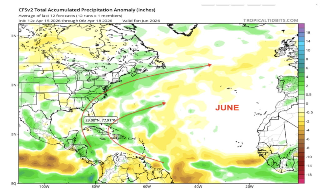
The red arrow is where storms could pass that can create this kind of heavy rain.
September is the peak of hurricane season
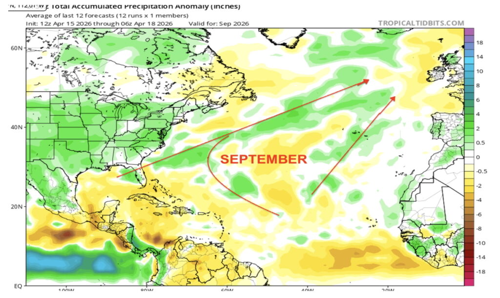
Taken together, it appears there will some mid-level moisture before El Nino is fully establish and suppresses formation
While it is best not to take any of these graphics as absolute given hurricane season begins in June, they are providing important input to the CAC forecast.
Summary of Conditions
THE CLIMATE ADAPTATION CENTER CAC, 2026 HURRICANE SEASON FORECAST
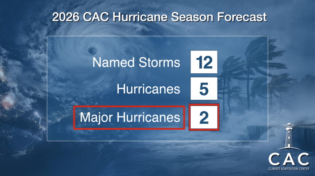
A Below Average Season But…
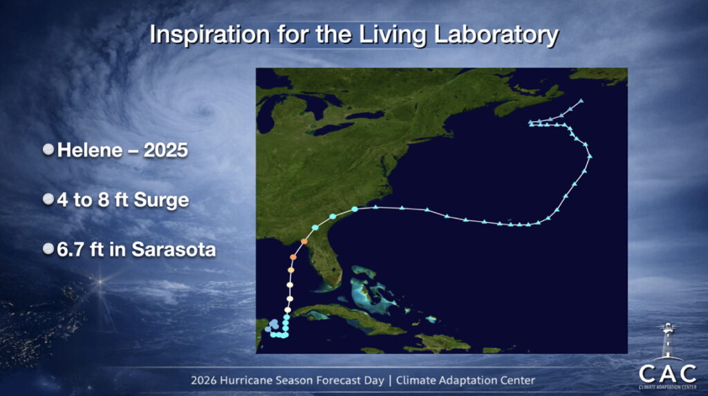
Remember, IT DOESN’T TAKE A DIRECT HIT FOR THE SUNCOAST TO EXPEREINCE EXTREME IMPACT!
Idalia and Helene were far of the coast but did millions to billions in damage.
That is driven by the fact hurricanes are bigger, slower moving and come on top of 7 inches of sea level rise since 2000 right here on the Suncoast.
Also, wind shear ebbs and flows no matter what is happening with El Nino. Should a weak period of shear happen, and a storm moves into the Gulf over the deep warm water, Rapid Intensification can and most likely, will occur. This is something we will watch very closely.
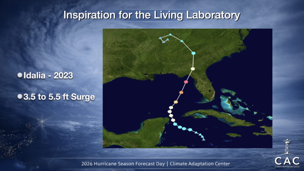
These are the reasons for the CAC Sarasota Living Laboratory. (See our article here)
And – One More Thing
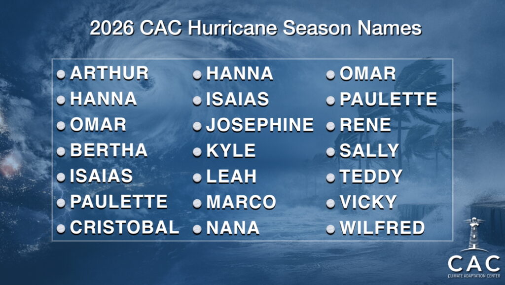
The National Hurricane Center shifted the baseline for average Atlantic hurricane season activity from 1981-2010 to 1991-2020, resulting in an increase in the average number of named storms from 12 to 14.
The CAC did an analysis of the past 10 years, and this is what we found. YIKES!
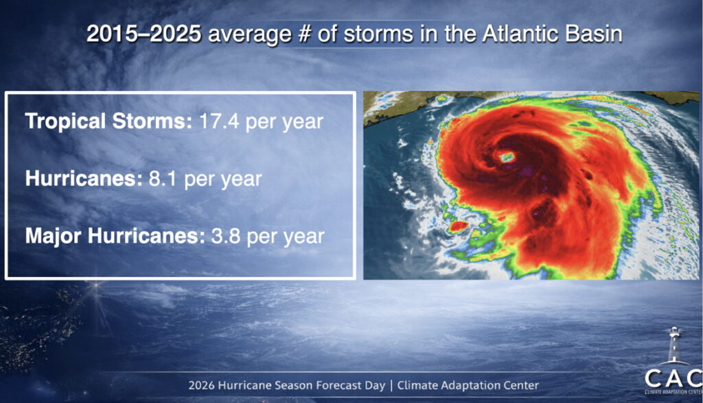
A look at historical storm data from 2015 to 2025 highlights a notable increase in storm activity compared to earlier decades. This trend underscores the importance of ongoing preparation, as climate warming is contributing to more intense hurricanes with higher rainfall, storm surge, and wind speeds.
A Major Hurricane strike on a population center in mid summers more intense heat is something to think about.
Rapid Intensification RT is a big risk again this year. RT can and does happen close to coastlines making the threat all the scarier. With climate warming, the lead time may be short for preventive action. YOU do need to be ready.
With an El Nino year likely, also remember 1992. It was an El Nino year. The first hurricane of the year formed in mid-August. It wasn’t far from the Miami Area. It rapidly intensified and changed the world. That hurricane was Hurricane Andrew.
Preparing for the Storms: Top 10 Actions to Take
Preparedness is the key to safety during hurricane season. Here are the top 10 steps recommended by the CAC to ensure that you and your family are ready:
- Create an Emergency Plan:
- Know your home’s elevation and evacuation zone.
- Establish a meeting place for family members in case you get separated.
- Identify a safe room in your home, ideally an interior, windowless space.
- Build a Hurricane Kit:
-
- Stock at least seven days’ worth of food and water (one gallon per person per day).
- Include medications, first aid supplies, cash, important documents, flashlights, batteries, portable phone chargers, and a battery-powered radio.
- Secure Your Home:
-
- Install hurricane shutters or impact-resistant windows.
- Trim trees and clear loose debris from your yard.
- Reinforce garage doors and secure outdoor furniture.
- Review Insurance Policies:
-
- Check your flood, wind, and homeowners’ insurance coverage.
- Note that flooding can occur outside designated flood zones, so consider adding flood insurance.
- Take photos of valuables and property for potential insurance claims.
- Prepare for Power Outages:
-
- Stock up on extra fuel for generators (always operate them outdoors).
- Charge all electronics before the storm.
- Have extra propane or charcoal for cooking if needed.
- Know Evacuation Routes and Shelters:
-
- Familiarize yourself with evacuation zones in your area.
- Identify nearby hurricane shelters, including those that accept pets.
- If evacuating, leave early to avoid traffic congestion.
- Protect Important Documents:
-
- Store copies of IDs, insurance papers, deeds, and financial records in a waterproof container.
- Keep digital copies in cloud storage or on a USB drive.
- Prepare Your Vehicle:
-
- Fill up gas tanks early, as stations may run out.
- Check tires, brakes, and oil changes before hurricane season.
- Keep an emergency kit in your car with food, water, maps, and first aid supplies.
- Park your vehicle at a safe elevation if flooding is a concern.
- Sign Up for CAC Storm Updates:
-
- Stay informed by subscribing to the CAC’s newsletter for storm forecasts and emergency updates. Listen carefully to storm information, evacuation orders and other lifesaving information when a storm approaches. Listen to the experts!
- Have a Post-Storm Plan:
-
- Avoid floodwaters and downed power lines after the storm.
- Document any damage for insurance claims.
- Be cautious of scams related to cleanup and repairs.
Why Your Membership Matters
The Climate Adaptation Center is committed to providing accurate hurricane forecasts, climate research, and actionable guidance to help communities adapt to our changing environment. By becoming a CAC member, you directly support this vital work and most of your donations are considered charitable gifts.
Membership comes with benefits, including access to detailed storm reports, early alerts, expert web articles, event tickets and great learning experiences and even specialized briefings. Scan the QR code below to join today and help us continue making a difference.
Conclusion
As the 2026 hurricane season approaches, preparation is more critical than ever. By understanding the forecast, following key preparedness steps, and staying informed through CAC updates, you can protect yourself, your loved ones, and your property. NOAA issues official Hurricane and Tropical Storm watches and warnings when a storm threatens. Let’s work together to build resilience and stay safe in the face of nature’s most powerful storms.