Don’t Delay – Get Ready Now!
The CAC is in its 4th year of operation and we are 100% focused on how climate warming is impacting the “here and now” disruptive climate induced events in Southwest Florida. Unfortunately, our growing and beautiful state is also ground zero for climate warming impacts.
Hurricanes have long been a concern here and around the US Gulf Coast and the Eastern Seaboard. That is why the CAC is focused on these storms that are ever increasing in number, slowing down their movements, changing their usual path and often exploding in intensity in just one day’s time. These changes mean it is no longer business as usual in Florida with its $1.4T annual economy and a growing population of almost 23M.
With sea levels rising an average of 9 inches since 1950 and the CAC forecast for an additional 11 inches by 2050, the impact of hurricanes and tropical storms will dramatically increase in the years and decades ahead. This will be true even if hurricanes remain similar to the way they are today. Every inch of sea level rise will increase the damage from storms, even if they are in the tropical storm or weak hurricane categories.
We are not as prepared as we could be and the 2022 season showed this in a big way. Given these changes in hurricane characteristics, we need to adapt to and mitigate the worst impacts by shifting our focus to preventing the worst impacts and not just responding after the fact. To do so means we need to totally rethink how we prepare for such storms with major redo in building codes, evacuation policies and education to name a few.
A Look Back At The 2022 Season
With 14 named storms last season, 2022 won’t be remembered as a record year but it just takes one and that one was Hurricane Ian. Sixty-five named storms in the past 3 seasons have created a climate-induced nightmare along the Gulf Coast…that is Not Normal!
Up until recently, 12 storms per season was the norm. With the uptick in storms since 2000, normal is now 14. Even by that new normal, Sixty-five is an incredible number!
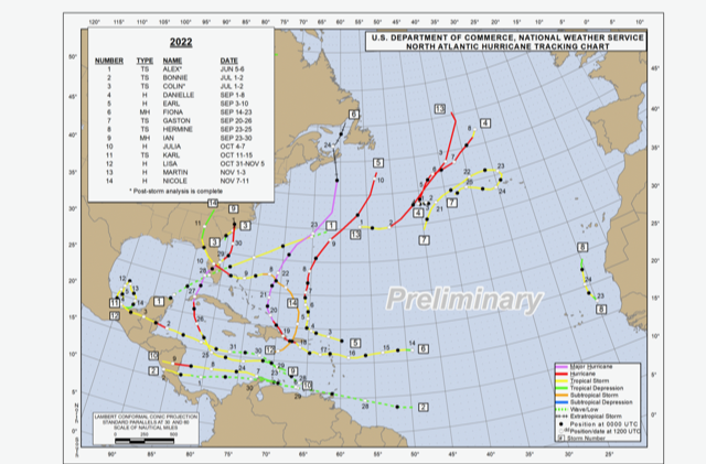
2022 Hurricane Report Card Image Credit: NOAA
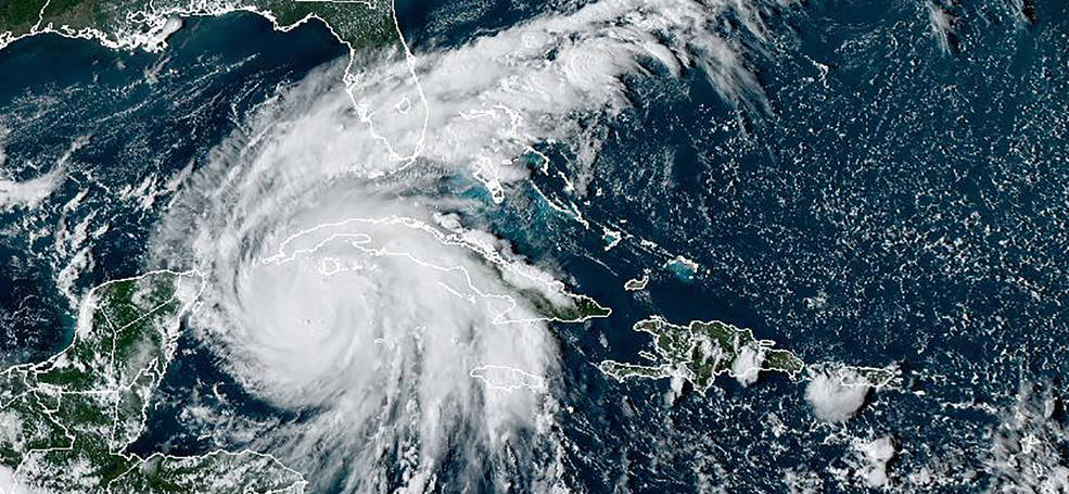
The past season featured eight hurricanes and two Major Hurricanes (Category 3-5 storms.) Four of the seven hurricanes were in the Gulf and three of those hit land — Fiona was the worst storm to ever impact Canada, Ian and Nicole were in our neighborhood. Most notable was Hurricane Ian that grew from a weak tropical storm to a 150 mph sustained wind monster hurricane in less than 48 hours! Ida did the same thing in 2021. Interestingly, the names Ian and Fiona have been retired from future use because of the death and destruction they caused.
Ian is yet another example of the new climate warming -induced super storm. It formed gradually and then found power just south of Cuba as it traveled over 5° warmer than normal water and exploded to Category 3 and did severe damage to western Cuba including wiping out the entire tobacco crop. As it passed over the island and entered the Gulf of Mexico, it went right into the slot the CAC warned about on November 9, 2021 — where a storm would likely travel and then hit Southwest Florida as a super hurricane. As Ian traveled right though that slot, the storm went though a second rapid development cycle in less than 48 hours and blew up to a 150 mph monster just before wiping out a good portion of Southwest Florida centered on Ft. Myers Beach with a 15 ft storm surge, a 500 year inland flood caused by 2 ft of rain, 150 mph winds and a long lasting Red Tide that still plagues the west cost of Florida.
Then a month or so later, Hurricane Nicole hit Florida’s east coast where it did serious beach damage and ruined many homes. Nicole was the first ever hurricane to strike the east coast of Florida so late in the season.
Category 4 Hurricane Fiona struck eastern Canada with historic force and damage. The trend for storms staying strong as they head north continued last year.
The 2022 season had some big numbers too. Over $120B in damage and almost 200 deaths including scores who drowned in storm surge flooding in Ft. Myers and the surrounding area.
Two main ingredients came together in the 2022 season as we had pointed out in our 2022 Hurricane Season Forecast when we said, “The CAC Is Forecasting A Severe Hurricane Season for 2022”.
Warmer sea surface temperatures and a lack of wind shear due to La Niña conditions in the Pacific helped create a season featuring storms unleashing nearly double the energy of a normal season.
A strange pause took place in July and August. Deep Sahara dust continuously blew out into the Atlantic and reached the Gulf at times as well. The dust filters sunlight and cools the sea surface temperature a bit and it keeps the air very dry, which further tamps down storm formation. Dust intrusions seem bigger and longer-lasting over the past few years and that may be a new factor that in the past was minor but now going forward may be a bigger issue. We will have to watch! The dust was thick because the desert seems to be expanding and the wind field over that area in summer is stronger.
What Will Happen This Year?
One of the big factors contributing to a very active season is how warm the seawaters are across the hurricane formation areas.
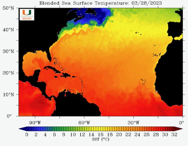
Atlantic Sea Surface Temperature on March 28, 2023 Image Credit: University of Miami/NOAA
This NOAA sea surface temperature map shows the warmer than normal temperatures from yellow to red. Our entire area of interest is already warm enough to spawn tropical storms and April is just beginning! Notice the warm Gulf Stream flowing from South Florida out into the North Atlantic and the all important Loop Current in the Gulf of Mexico which is already approaching 80°F.
Let’s zoom in closer to home.
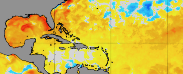
Gulf of Mexico sea surface temperatures March 29, 2023 Image Credit: NOAA
There is a warm loop current in the Gulf of Mexico that is already 4°C warmer than normal, red areas, and the same can be said for all Florida coastal areas, the Bahamas and the Atlantic east of the Bahamas. The entire hurricane formation area is mostly warmer than normal. Any storm traveling or forming over or traveling over the brown and red areas areas will get a big energy boost. It is this condition that can fuel the rapid intensification of storms from tropical storm to major hurricane in a day or so. Only in a climate-warmed world can this happen as often and as rapidly as it has in recent years. Ian was exactly such a storm.
Like last year, there is a La Niña in the Pacific. When there is, the wind shear that inhibits hurricane development is often less in the Atlantic Basin hurricane formation area. The latest models shown in the IRI graph below indicate that La Niña is ending and a weak El Niño could replace it by the end of hurricane season in November. The neutral zone between the two is shown between the two red horizontal lines.
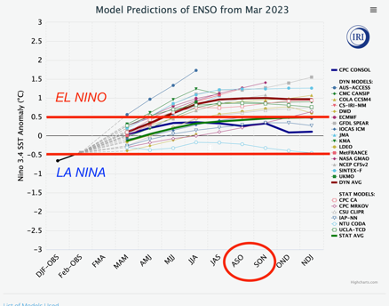
ENSO 2023 Forecast Image Credit: International Research Institute, Columbia University
The following image shows sea surface temperatures in the eastern equatorial Pacific Ocean as of early April, 2023. The warm surface waters in the eastern Pacific are an indicator of a developing El Niño.
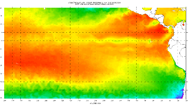
April 3rd 2023 sea surface temperature – Eastern Pacific Image Credit: NOAA
Most models show a transition from neutral or weak El Nino (+.05°C to +1.5°C) conditions as the season progresses meaning wind shear over the Atlantic could become a factor limiting hurricane strength for the peak hurricane season from August through October.
Wind shear is the change of the wind in direction and velocity as one goes higher in the atmosphere. Wind shear for example would be an easterly component wind at the surface at 10 mph and a westerly component wind of 50 mph at 10,000 ft. When there is wind shear, tropical systems get blown off their axis but when the wind shear is light, tropical storms can more easily organize vertically. In that case the eye of the storm is vertically stacked from sea level to the stratosphere giving it the power to become a Category 3-5 storm.
The 2023 CAC Hurricane Season Forecast
These two major components, ocean temperatures and La Niña/El Niñ0, are aligned in a less powerful way than last season. Consequently, the CAC is forecasting a normal to slightly above normal season, similar to last year — assuming the dust clouds entering the Atlantic and Gulf of Mexico this year are normal. In other words, a normal dust pattern blowing into the Atlantic from the Sahara would mean hurricanes will form in July and August unlike last year, but a developing El Niñ0 especially could help tamp down formation during the peak season. The early season may pose a higher threat than normal. Storms form in the Caribbean early in hurricane seasons and with the excessive Gulf water temperatures and weak wind shear early in the season, we have to be extra careful.
The CAC is forecasting 14 named storms for the 2023 season. We expect at least 7 to reach hurricane strength and 2-3 to become Major Hurricanes. We also expect several of these storms to exhibit rapid intensification and our focus needs to be high during the June though August period when warm SST’s and neutral conditions in the Pacific will be most favorable for storm development.
Should a storm form in the south central Gulf this year, there is the chance that it could rapidly intensify and become a major storm in the one or two days before it makes landfall. This is a new regime and it requires a different approach because so many people live so close to the water with potentially little time to evacuate.
The hurricane names for this season are: Arlene, Bret, Cindy, Don, Emily, Franklin, Gert, Harold, Idalia, Jose, Katia, Lee, Margot, Nigel, Ophelia, Philippe, Rina, Sean, Tammy, Vince, and Whitney.
What should you do?
Be sure you have a plan in the event a storm comes close. Will you stay in place or evacuate? Where and when will you go? Are your exit routes high enough above sea level to give you time to leave? It is possible low-lying escape routes you will use will go under water before a storm even strikes. Sea levels are up 9 inches already and that means stronger storms will bring in ever increasing storm surges and escape routes could be under water well before a storm arrives.
Speak to your public officials. Ask them how far above sea level your escape route is so you know the landscape before an event happens.
The US has been good at responding to climate induced natural disasters. Last year these events resulted in damages of $165B+ in the US alone. In recent years, one of the main cost drivers has been the number of Category 4 or 5 hurricanes making landfall, including hurricanes Harvey, Irma, Maria, Michael, Laura, Ida, and Ian. Just since 2017, Florida has experienced Irma, Michael and Ian!
We need to plan for a different climate than the one we knew in the 1990s and prevent the worst impacts by being truly prepared. Let’s not learn the hard way! The cost can be managed somewhat by shifting focus from reaction only to preparation first and reaction after an event. Building codes need an immediate upgrade. They were designed mostly during the 1990s when climate was much more tame than it is now. The climate has already changed and our codes have not.
Be sure you KNOW YOUR ELEVATION. Your life could depend on it should a storm hit our communities this year!