
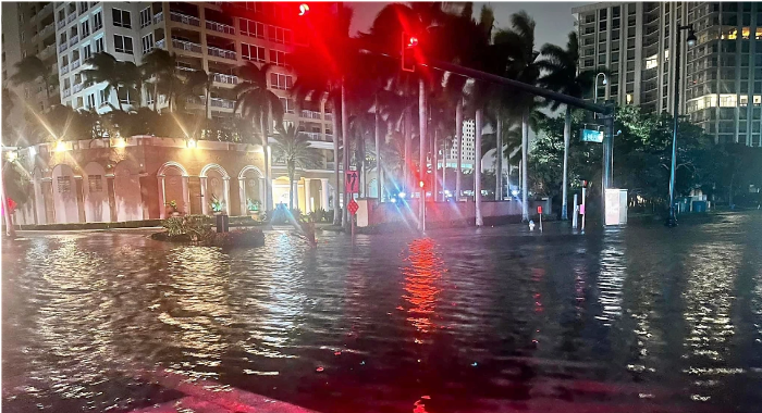
Downtown Sarasota streets near the Bayfront were flooded for a time. Image credit: Sarasota Police Department
Sarasota’s climate scientist says ninth Atlantic basin storms typically have been seen much later … if at all.
Sarasota and Manatee counties were about 150 miles east of Hurricane Idalia’s circulation center this week, though the storm still delivered damaging and flooding storm surge effects, driving salt water across beaches and bayfronts, into waterfront neighborhoods and downtown streets in Sarasota, Venice and Bradenton.
Dr. Bob Bunting, the founder of the Sarasota-based Climate Adaptation and Mitigation Center, for more than 20 years forecast tropical systems for the National Oceanic and Atmospheric Administration and continues to do so today for his own organization.
Bunting, in his annual tropical-weather season outlook last spring, predicted 14 named storms would form in the Atlantic basin. Idalia was number nine.
NOAA recently revised its estimates of a “nearly-average” storm season to above average, increasing to 21 named storms while citing warmer than average ocean and gulf water temperatures as a driving factor. Vince would be number 21, with no storm name beginning with Q or U.
Bunting this week discussed with the Community News Collaborative’s Catherine Hicks the season remaining, Idalia’s unusual behavior, a historical perspective on “I” storms and the myth that Sarasota is protected by Native American folklore.
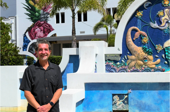
Bob Buntng’s Climate Adaptation Center operates out of downtown Sarasota Image credit: Catherine Hicks / Community News Collaborative
How has the number of severe storms increased over time?
The number of category four and five storms, which are the worst storms that the Earth has to throw at us, especially at the scale they occur, has doubled since 1960. Satellites began to be used to observe and predict the patterns of the storms forming within the Atlantic basin in 1960, and since then the number of these intense and dangerous storms has doubled. We have had now, since 2017, seven category four or five storms in the Gulf of Mexico — Hurricane Idalia briefly reached category four before making landfall.
Why are storms like these increasing in numbers?
Simply put, the climate is so much warmer than it was in 1990, and people don’t realize that a degree from a climate perspective is a huge amount of energy. We have a record warm Gulf of Mexico, and not just on the surface — these temperatures of roughly 86 to 90 degrees — are now deep into the Gulf of Mexico. Where we might have had that only on the surface, a few feet deep, say 30 years ago, now we have that reach down over 100 feet. This is like rocket fuel for hurricanes. So, we are living in a world where the climate has already changed, and there is more change coming. The Gulf of Mexico is like a hot tub, and this is just unprecedented in human history.
What characteristics made Idalia unique in the level of threat to the Florida Gulf Coast?

What are some of the specific challenges associated with storms along the Gulf Coast?
We saw a lot of them with Idalia. Wind is one issue, in the area where a hurricane comes ashore. Water is the biggest issue. When you think about this storm, the coastline from Venice all the way to the Florida Panhandle, basically Alabama; every single coastal community was impacted by high water by Idalia. St. Armands Circle has basically been underwater for an entire day due to flooding. People look out their windows and see that their roads aren’t underwater, so they don’t believe they have an issue, but if they tried to get over the bridge (during the storm), it’s closed — the main escape route from south Longboat Key and Lido Key onto the mainland, and you can’t get over it. For Sarasota, this is a minor situation, compared to what it could’ve been if the storm was only 30 or 40 miles closer than the 175 miles off the shore I estimate it was. It would be much different. In one sense, we haven’t received a direct eye of a storm in a long time, but we are getting major impacts every year. Our whole community has been paralyzed for two days. That’s a major impact. Tens of thousands of people evacuated, and with good reason.
Are coastal communities within Florida prepared to handle increased storms?
We’ve had 9 inches or more of sea level rise, depending on where you are in the state. We have a very shallow coastline, and half of the state is below 10 feet elevation. So we’ve lost our buffers, then of course economic development and population growth. As 22 million people (moved here), they have put most of the expensive real estate in the worst possible location as far as storms go — and of course, I understand, I live in Florida too — I want my view with the beach, but we have to learn to live with this if we’re going to survive.
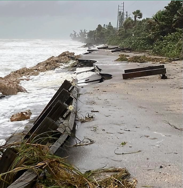
A portion of Manasota Key road collapsed near Blind Pass Image credit: Sarasota County
What are some of the economic impacts of the increased storm activity?
The economic impacts we’re seeing are (unprecedented)… Hundreds of billions of dollars of damage in Florida in the last few years. I mean, in 2018, Michael hit almost the exact same spot as Idalia hit. So imagine that since 2018, in five years, they’ve had a category four and a category five hurricane. Anyone who owns a home in Florida and is paying an insurance premium right now is paying a lot more money because of the storms we’ve had since 2017.
Why are all of the recent impacts of storms by ‘I’-named storms?
Starting with Irma, all of the ‘I’ named storms have been devastating to Florida — Irma, Ida, Ian, Idalia. This is because the seasons are longer, and we are inevitably getting to ‘I’ earlier and earlier. ‘I’ hurricanes, if we ever got to them, we got in late October, early November. But, here we are, in August, already with an I. And if you look back, it’s getting earlier each year – Ian, Ida and Irma all occurred in September. So simply put, more hurricanes. We’ve already had 94 named storms in the Atlantic basin in four and a half years — if this were 1970, the average number would have been 45. It has more than doubled.
When did Sarasota last suffer a direct hit that could offer an indication of what an eyewall landing would look like?
That’s the problem — the last time we had a storm of this proportion through the metro area of Sarasota was Hurricane Donna in 1960, a category three storm when it hit. But then, sea level was nine inches less. The barrier islands were lightly populated in Sarasota and Bradenton — the entire area’s population has doubled and tripled. So currently, what we’re facing is a changing climate that will produce many more severe hurricanes, on top of a sea level that has risen, on top of a rising population. If you put all that together, that’s why our risk is so high, and will continue to be high. And, I’m just going to say, there is no Indian blessing protecting Sarasota. Sarasota will experience a direct hit by a hurricane. Every time one goes by that we’re not in the center of, the risk increases that the next time, it will be us — but we have a 1,200 mile coastline in Florida, it’s going to take a while for every community to experience the eye of a hurricane.
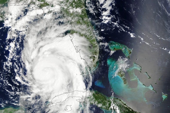
As it moved into the Gulf of Mexico, Idalia intensified into a powerful hurricane. Image: NOAA
Catherine Hicks writes about the environment for the Community News Collaborative. You can reach her at chicks@cncfl.org