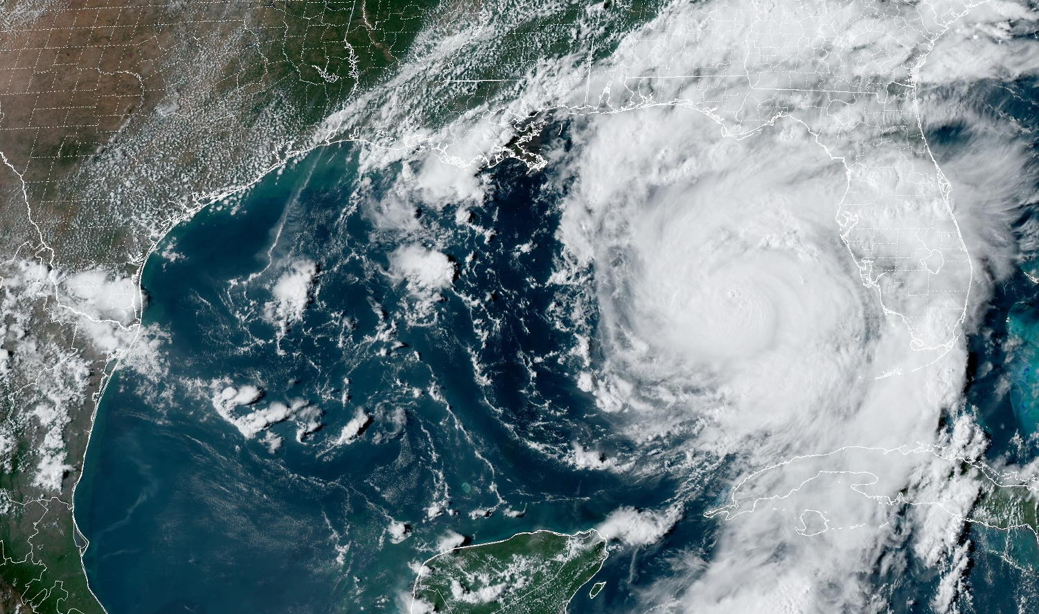
title image: GOES East Geocolor image acquired 5:01 pm EDT
Hurricane Idalia UPDATE – Tuesday, 29th August – Noon EDT
Hurricane Idalia Status
Hurricane Idalia is rapidly intensifying and predicted to become a Category 3 Major Hurricane by the time it makes landfall Wednesday morning in the Big Bend area of the Fliorida coast.
Idalia has formed a 20 mile wide eye as of this morning.
Sarasota: a Storm Surge Warning, Tropical Storm Warning and Hurricane Watch is in effect
A Hurricane Warning is posted for coastal Manatee County
Are you ready?
Storms that begin with the letter “I” have not been good to Florida! (Remember Ian…?)
The path of Idalia is becoming more reliable now BUT a small shift of the center of the storm to the east from its projected path could bring much more severe impacts to the mid-Florida Coast from Tampa Bay to Venice.
Storm Surge Forecast
At this point, storm surges and high surf stand to be the most critical impacts, with 3 to 5 ft of peak surge in coastal Sarasota County, 4 to 7 ft in Manatee County and Tampa Bay and perhaps 10 to 15 ft in the Big Bend area, where Hurricane Idalia will make landfall.
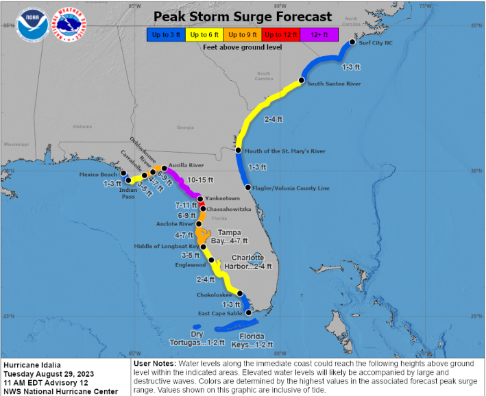
NHC Storm Surge Forecast for Hurricane Idalia
If you live on a barrier island, LEAVE. If you are in an evacuation zone that has been told to evacuate, LEAVE.
Your escape routes may flood long before the storm hits peak.
Tonight and tomorrow morning will be rough along the shore. High tide tomorrow in Sarasota will be around noon and onshore gale force winds will likely be pumping water onto the shore.
Storm Path Forecast
Idalia’s path forecast is shown below with applicable warnings. Idalia’s eye may pass anywhere within the forecast cone. Remember – hurricane impact will be felt well outside the cone.
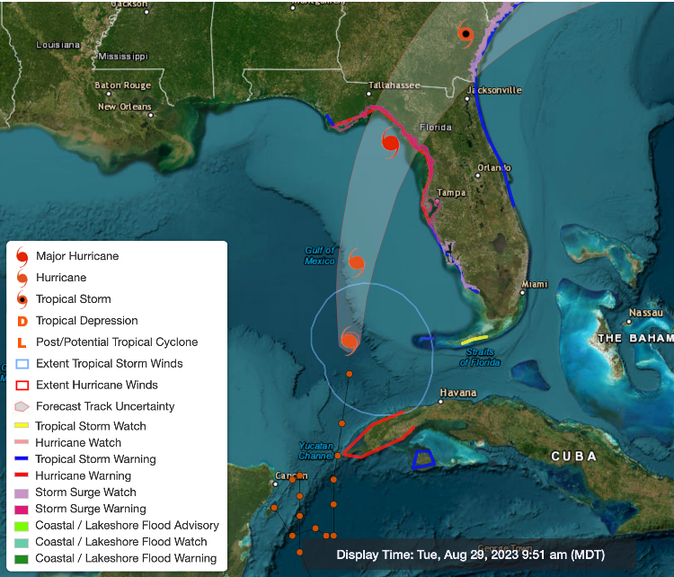
Hurrican Idalia Path Forecast
Sarasota Impacts
Winds in the Sarasota Metro Area will gust from 50 mph at Sarasota Airport to 60+ on Longboat Key and to hurricane force in northern Manatee county.
The winds around a hurricane are counterclockwise, the storm surges will be worst after the center of the storm moves north of your location. Because this storm will have very intense characteristics on its eastern side, areas along the coastline and near the coastline are at higher risks than you might think.
That means as the winds shift to onshore and blow at gale or higher force, water will surge into the coast.
Do not second guess!
Heavy rains from 2 to 6 inches are expected with heavier amounts further north. Street flooding will be common.
Gale force winds should develop by late afternoon and continue throught the night and into Wednesday morning.
A Category 2 or 3 storm today will have much higher surges and tides because sea level is 9 inches higher than it was in 1950. That is a lot!
Also increasing the tides is the Supermoon, which will be full tomorrow. The impacts of the high tides, 9 inches of sea level rise, record warm sea surface temperatures combine to increase the threat. The Climate Has Already Changed!
Remember the CAC had a nearly perfect long range and short range forecast for Hurricane Ian.
Make intelligent science-based decisions. Protect your property but be sure to protect yourself!
Now Is a Good Time to:
- Consider if you are in a low-lying area and could face high tides and storm surge
- Figure out where you will go if you need to evacuate
- Stock up on water, batteries and essentials now while you have time
- Above all get prepared and watch what is going on in the tropics
And Remember:
- Sea levels are already nine inches higher than they were 50 years ago so minor storms have bigger flooding impacts
- Escape routes can be very vulnerable because roads in many areas have not been raised
- Power can be off for days in some areas depending on the severity of winds and surge. Consider this in your planning
Help Us Spread the Word
The CAC is planning to continue updates until the storm is gone. You may view these articles on the CAC website, at Sarasota Magazine, or if you sign up for the CAC monthly newsletter, you will automatically receive an email update in your mailbox as soon as it is posted.
Not on our subscriber email list yet? You can subscribe by clicking the button below and filling out the contact form on the following page.
If you find this content valuable, please forward this email to friends and colleagues and recommend they subscribe so they can be informed. Every bit helps and we thank you for your support.