Image Credit: NOAA
El Niño is having an impact on weather this winter, but its disappearance may affect the 2024 Hurricane Season
El Niño is a complex climate phenomenon occurring in the Pacific Ocean that can impact weather patterns around the world. Its warming sea surface temperatures in the central and eastern equatorial Pacific Ocean can lead to changes in atmospheric circulation patterns, resulting in shifts in weather patterns across different regions.
The impacts of El Niño can vary depending on the strength and duration of the event, as well as other interacting climate factors.
El Niño and Florida Winters
Florida’s winter weather is usually mild and filled with sunshine, making it an attractive destination for snowbirds and tourists seeking respite from harsh winter conditions in other parts of the country. It is a gift to those of us who live here during increasingly hot summers.
But this is no ordinary winter. It’s an El Niño winter. And a strong one.
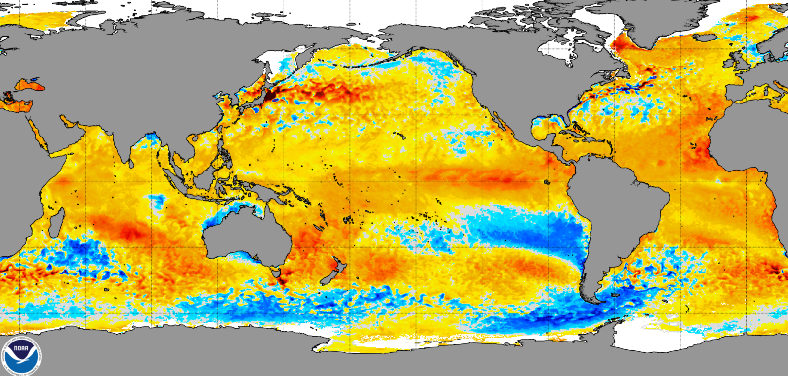
Right now Pacific sea surface temperatures are just below “Super El Niño” status.
When SST (sea surface temperature) anomalies in critical parts of the Pacific Ocean have warmed to 2°C or more above normal, a Super El Niño event is considered to be underway. Super El Niños are rare, with only three occurring since the 1950s—in 2015-16, 1997-98 and 1982-83. This year’s El Niño SSTs should peak at or just below 2°C.
In most El Niño winters, Florida is wetter than normal from January to March. That is because the jet stream that controls the storm path is pushed south. That is exactly the case right now.
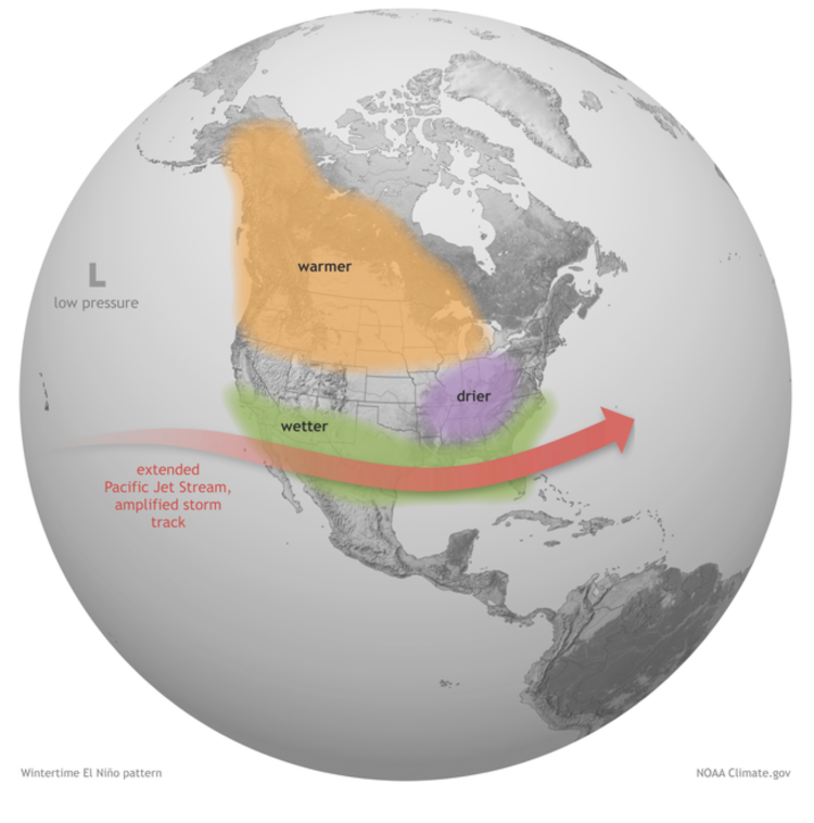 As winter continues and the jet stream remains far south, streaming across the Gulf of Mexico, storm systems will continue to move across the Gulf and into Florida with more rain and clouds than we have seen, especially in the past few years when La Niña was in full swing! This can lead to increased flood risks, replenishment of water supplies, and beneficial conditions for agriculture.
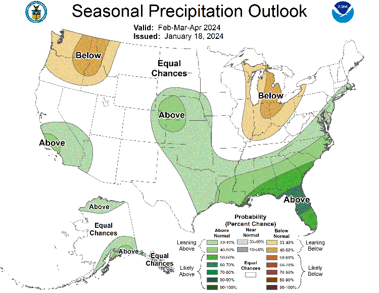
Above normal rainfall is likely to continue, a welcome forecast for parts of Southwest Florida, where a severe drought is waning after a record dry and hot 2023.
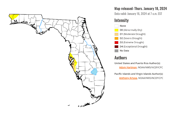
Presently, most of the state is now drought-free, with the exception of moderate drought in Southwest Florida and abnormally dry conditions in the northwest.
Beyond its effects on regional weather patterns, El Niño can also influence large-scale climate patterns. For example, El Niño can alter the North Atlantic Oscillation (NAO), a climate pattern that affects winter weather in the eastern United States and Europe. During El Niño, the NAO tends to be in a negative phase, which can lead to colder and snowier conditions in the northeastern United States.
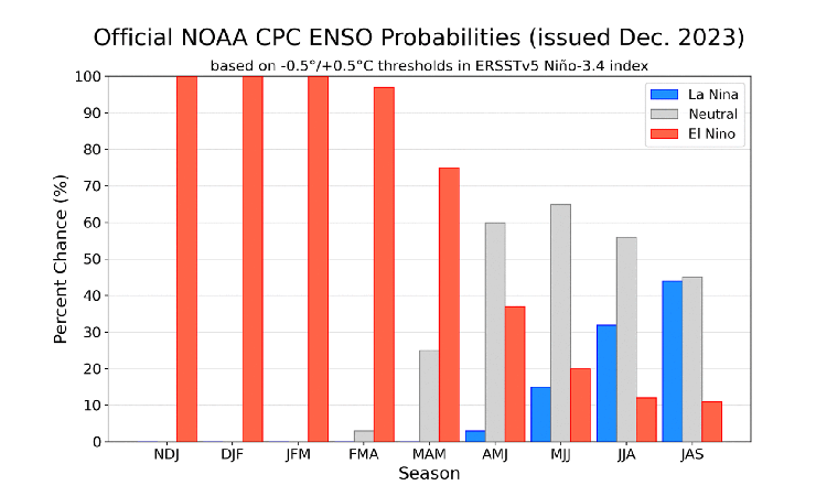
The 2024 forecast going forward is for El Niño to disappear by late spring or summer. That’s pretty common for strong El Niños. The average El Niño lasts nine to 12 months.
Impact on the 2024 Hurricane Season
The disappearance of El Niño could have a significant impact on the 2024 Atlantic hurricane season, especially if La Niña reappears during the hurricane formation months, which peak in August through September.
Typically, El Niño conditions tend to suppress Atlantic hurricane formation by creating stable atmospheric conditions and increasing vertical wind shear. That didn’t appear to happen in 2023, which recorded 20 named storms and an average number of hurricanes.
With abundant, possibly record-warm ocean water in the Atlantic Basin for the upcoming hurricane season, together with the disappearance of El Niño, the 2024 hurricane season may get extra active and may even produce an above average Atlantic Basin hurricane season in 2024.
Hurricane Day Is Coming!
This year, the Climate Adaptation Center will release its 2024 hurricane forecast at a new event – Hurricane Day! The Hurricane Day 2024 event is scheduled for Thursday, April 4th, in the Selby Auditorium of the University of South Florida, Sarasota-Manatee campus. The event will run from 8:30 am until 12:30 pm.
Hurricane Day 2024 will feature CAC CEO Bob Bunting and world-class hurricane experts who will forecast the 2024 hurricane season. Insurance and infrastructure experts will join in to discuss how we can adapt to the increasing storm impacts expected in the future by preparing for them in advance and shifting from reaction to prevention. More details will be forthcoming in the near future.
Hurricane Day 2024 should be informative, interesting and actionable. Mark your calendars!