A Signature of a Warming Climate?
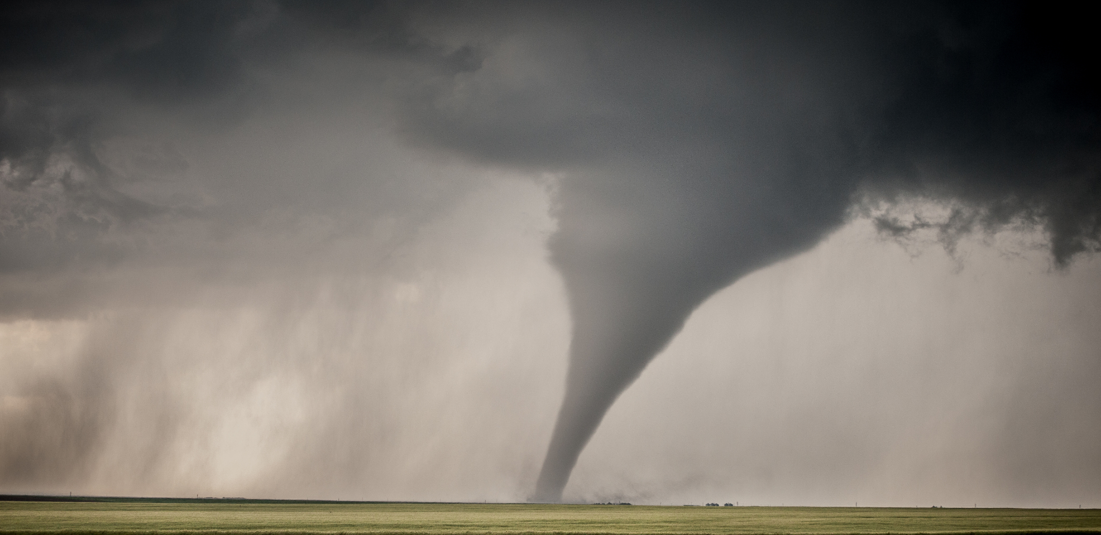
December’s Deadly Tornadoes
As the climate warms, the chaos continues. Two years of unprecedented weather events unimaginable just a decade ago are occurring worldwide and the U.S. is no exception. During that time, 51 named tropical storms formed in the Atlantic basin and 40 climate and weather events with losses of $1B or more occurred in the U.S., the latest of which is the unprecedented outbreak of tornadoes in December 2021. What is going on?
December 10th will long be remembered as the day of a rare and perhaps one of a kind tornado outbreak. The central U.S. between the Rockies and the Appalachians are accustomed to tornadoes in April and May as spring storms are fed by a combination of cold dry air penetrating the continental U.S. from Canada and warm moist air from a seasonally warming Gulf of Mexico. When the cold dry air moving south from Canada moves over the warm moist air moving north from the Gulf the instability creates severe thunderstorms. December 2021 has been exceptionally warm nationwide and the Gulf of Mexico has therefore remained extremely warm too. The setup was perfect for a mega event on December 10 as we show in the situation analysis below. Sea Surface temperatures were extreme at about 5°F warmer than normal!
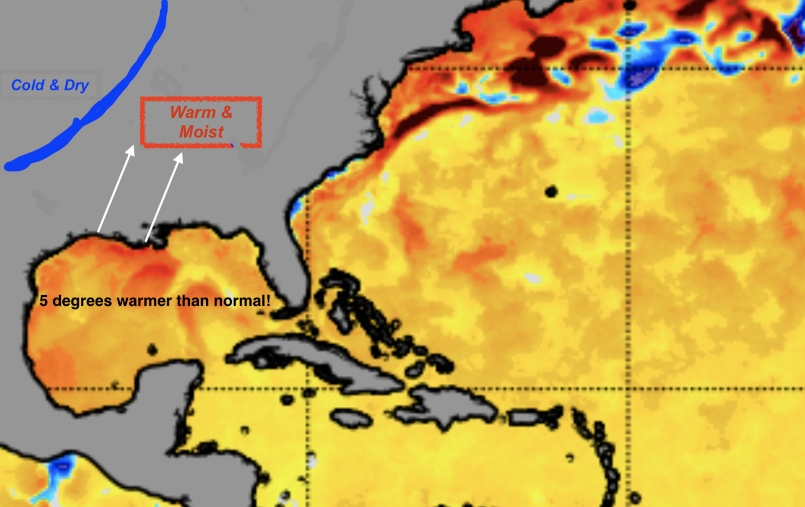
Abnormally warm sea surface termperatures in the Gulf of Mexico fueled warm, moist air moving north. Image Credit: NOAA
Southerly winds from the Gulf were blowing moist air into the Mid-South states including Kentucky. Meanwhile a cold front (the blue line in the image above) was knifing its way south from Canada.
Tornado Formation
The plot thickens as thunderstorms forming along the cold front were aided by significant vertical wind shear — the change of wind speed and direction with height. Wind shear interacts with thunderstorms to either increase or decrease vertical draft strengths. In this case winds were blowing at the surface from the south to southeast while winds aloft were blowing from the northwest. This combined to create a net wind shear of about 60 mph and a very unstable situation as the warm moist air was overridden by cold dry air.
With this perfect scenario Mother Nature responded with over 50 tornadoes, demolishing a large area of the Midwest ranging across eight states. Kentucky took the brunt with a massive family of tornadoes that dropped down from a long-lived supercell thunderstorm. That one storm held together for about 300 miles. The tornado from this supercell traveled a record 230+ miles, reaching at least EF4 and possibly EF 5 levels. There has not been an EF5 tornado in the U.S. for about 10 years. Only two EF5 tornados have been recorded in the month of December.
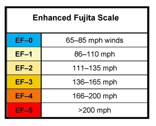
Enhanced Fujita (EF) tornado classification. Typically, the EF classification level is determined based on the level of damage inflicted by the storm.
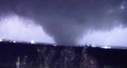
Tornado near Mayfield, Kentucky, Dec. 10, 2021 Credit: ABC News
It is not unusual to have unstable air masses in the U.S. in winter. It is normal and is the reason we have many more storms in winter than summer. But severe thunderstorms spawning swarms of EF 3 to EF 5 tornadoes are not normal.
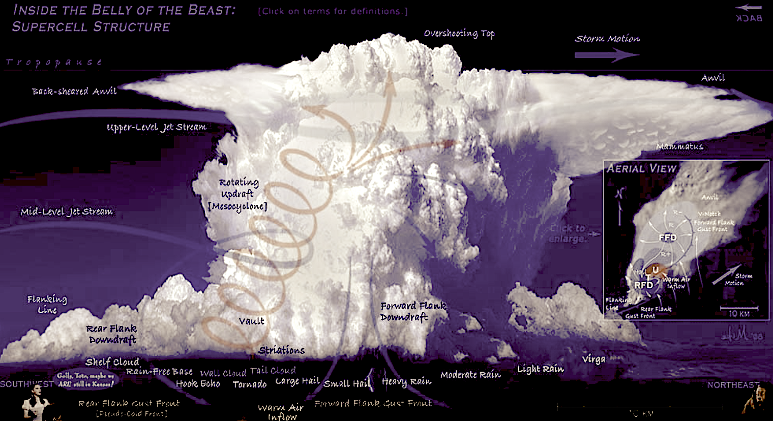
The storm that spawned the Mayfield tornado was a supercell thunderstorm.
Supercell thunderstorm development.
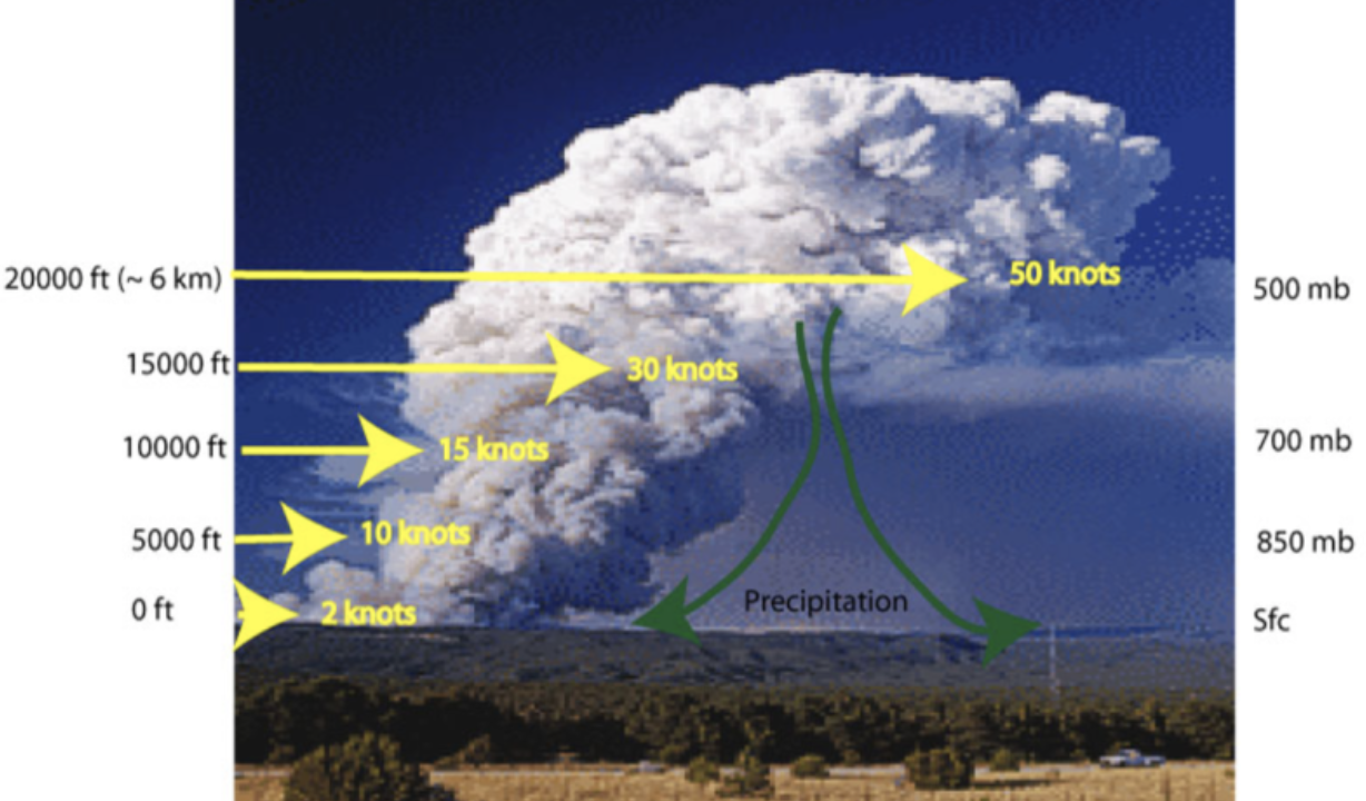
A big component of how supercells work is wind shear. Wind shear pushes the cloud downwind so it is tilted with height. This allows the rising air from the base of the cloud to move up into the cloud while the rain falls downwind. In normal thunderstorms the rising updraft is diminished by cold rain falling though it, which kills the updraft and ends the storm. The tilted updraft can also rotate, and when it does the results can be catastrophic as large tornadoes dip below the tilted updraft and become tornadoes on the ground.
Tornado formation in a supercell thunderstorm
December 10th, 2021
Abound 8 pm on December 10th NOAA weather radar showed two supercell storms in the southeastern U.S. The monster storm shown approaching Jonesboro, Arkansas in the image below had already become fully developed by about 6 pm CST.
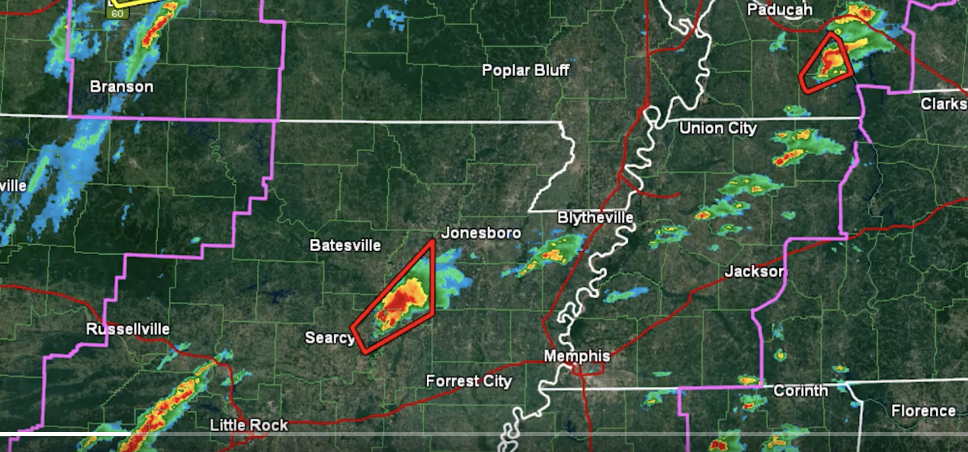
Credit: NOAA/NWS
The storm, shown below in a time lapse, was one of at least 50 tornado-producing storms but this one was the big one. It raced across flatlands and traveled to the east-northeast at speeds averaging 50 mph! The tornado was on the ground for at least 230 miles making it the longest and strongest tornado in the history.
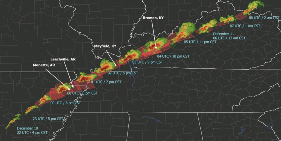
Credit: NOAA/NWS
The Doppler weather radar image below shows the couplet of the wind in the top box. Look closely and you will see a red area next to a green area near Mayfield, Kentucky. That, my friends, is the spinning tornado in the photo shown earlier. The bottom radar image shows the reflectivity of the water droplets and one can easily see the super cell thunderstorm to the north with the tornado just to the west of Mayfield. The purple area is the most intense radar signature, showing large debris in the vortex.
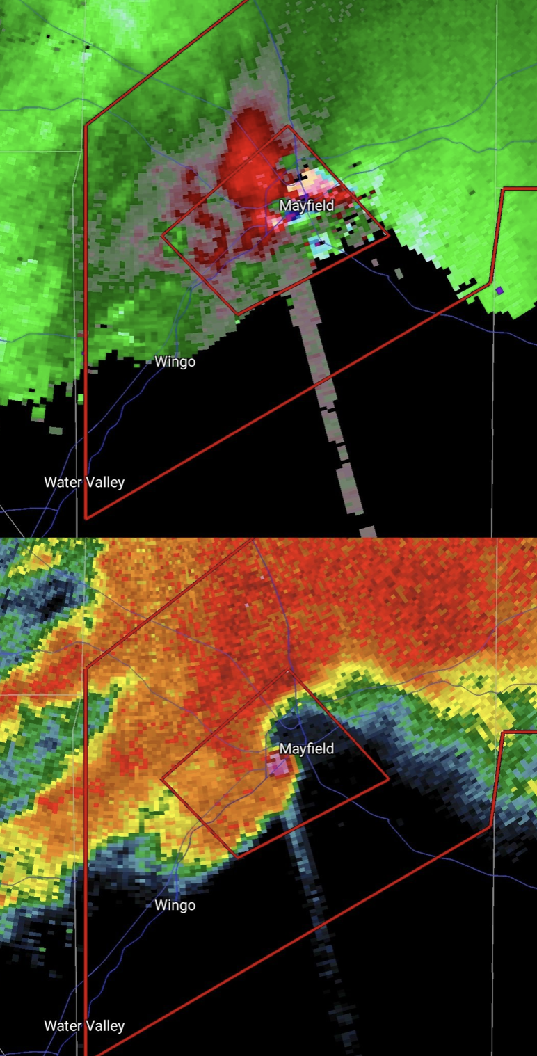
Doppler weather radar imagery showing the tornado approaching the town of Mayfield, Kentucky. Credit: NOAA/NWS
The storm was so strong, so wide and so long lasting it created a debris cloud that could be detected by weather radar miles away, the yellow-green cloud shown in the white outline below. It was reported that someone found a letter the next morning in a field from an address 125 miles away! Radar showed that the debris cloud extended more than 37,000 feet above the ground.
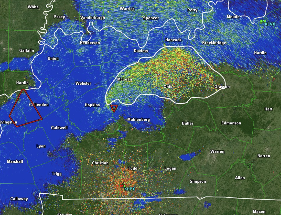
Debris cloud from the tornado as it passed through Kentucky. Credit: NOAA/NWS
A NOAA team is on the ground analyzing the damage inflicted by the tornadoes. The Mayfield storm was rated at least an EF4, but I believe it will be raised to an EF5 in the days ahead. The fully loaded rail cars that were tossed off the train tracks near Mayfield suggest that winds were about 200 mph — well within the EF5 range.
How is Climate Warming Affecting Tornado Events?
Before closing let me address the role of a warming climate in this extreme weather event. Not only did it become the 19th billion-dollar climate/weather event in 2021 but it also cost at least 88 lives. Many more are still missing.
Major kudos go to NOAA and its National Weather Service for a brilliant early prediction of this rare event. The National Severe Storms Forecast Center made the call hours before the first event. The actual storms are plotted on the forecast shown in the following image and it was a near-perfect. Weather and climate forecasting today is very sophisticated and remarkably accurate. It should not be ignored.
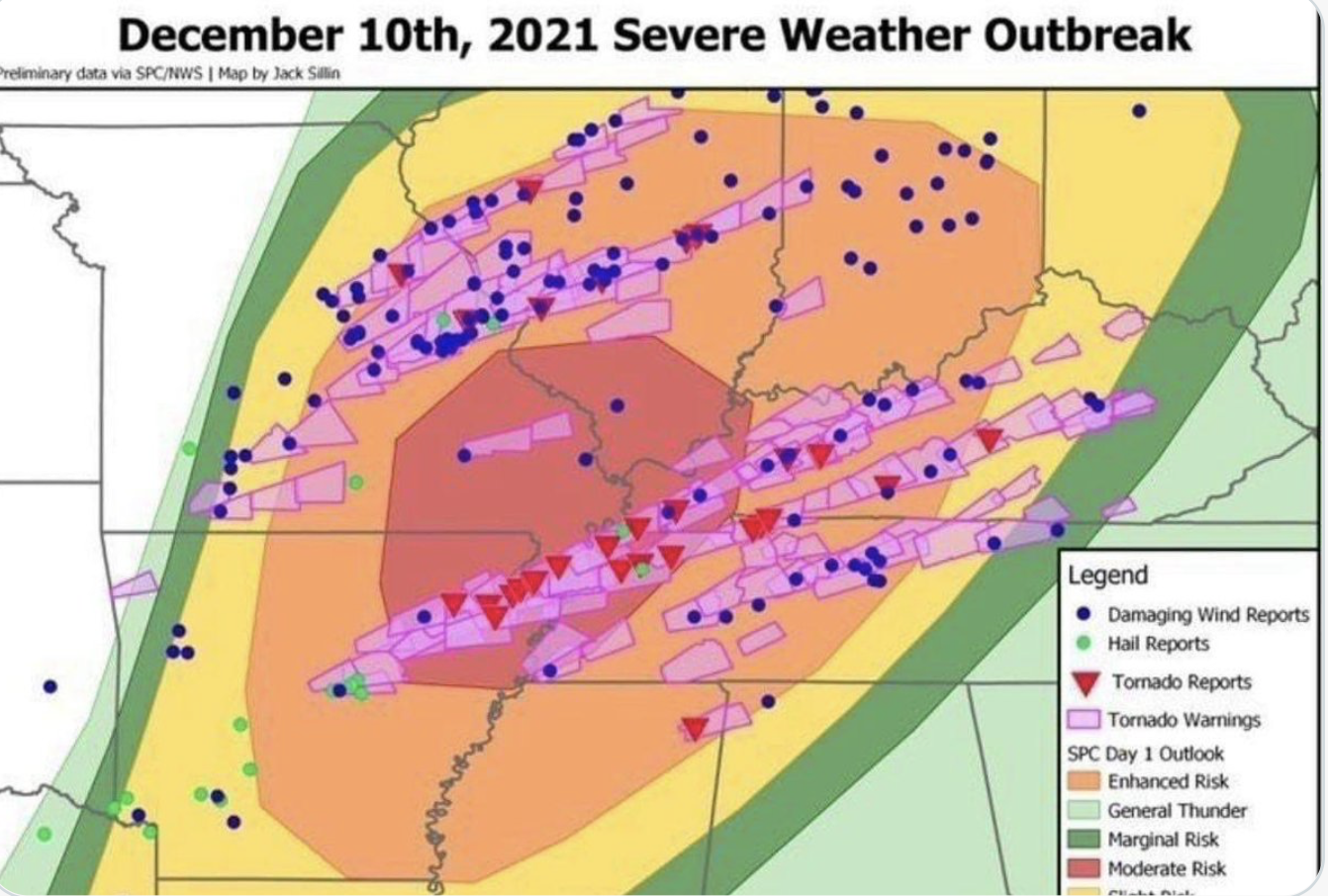
The NOAA/NWS December 10th forecast, overlayed with later wind and tornado reports. Credit: NOAA/NWS
In recent years the tornado belt, the so-called “tornado alley,” has been shifting, as shown in the following figure.
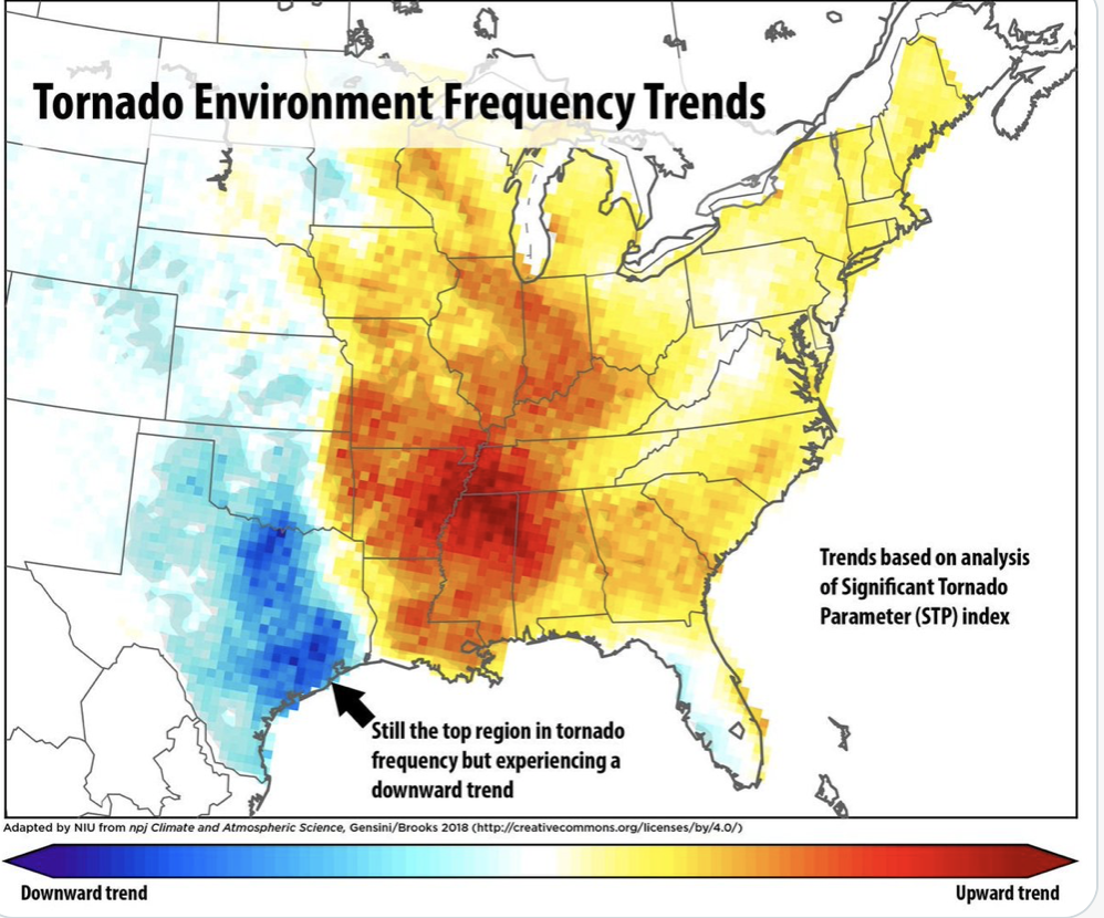
Credit: Nothern Illinois University
It’s clear from this NIU study that tornadoes are shifting from the Oklahoma, Texas, Kansas area to the mid-south. In my opinion, it’s happening because as the earth warms, the western U.S. is drying out, its vegetation is becoming more desert-like, while severe droughts and atmospheric heat domes are more frequent. At the same time, the tornado belt is migrating closer to the moisture source provided by an ever-warming Gulf of Mexico. Tornados will still occur in traditional areas but tornado outbreaks in a warming climate are now becoming more frequent and are increasingly moving beyond their historical limits as the climate patterns shift.
Tornado outbreaks are not the best candidates for the attribution science studies that linked individual flood events, hurricanes evolution, and droughts directly to climate warming. That said, the shifting weather patterns that can affect tornado formation are there and they are happening because of the rapid rate of climate warming — now double what it was in 1990.
Look for more extreme events more often. Sadly, we seem to be slow learners and the cost we are paying is rapidly increasing across the board. We can make choices to limit the impacts of these climate disruptions but the final chapter of the climate book for the next few centuries will be written in the next 10 to 30 years one way or another!
Please join us at the CAC to help our communities understand, adjust and adapt to the climate impacts that are sure to come in our own lifetimes.