
Credit: U.S. Navy photo by Petty Officer 3rd Class Joshua Scott.
Idalia provides some clues
The latest hurricane to impact Florida was Hurricane Idalia. The storm made landfall on Florida’s Gulf Coast at around 7:45 a.m. ET on Wednesday, August 30 near Keaton Beach, about 75 miles southwest of Tallahassee, Florida’s capital city.
But even more noteworthy is it took just over 24 hours for it to strengthen from a Category 1 hurricane to a Category 4, before weakening slightly as it ran into the Florida Panhandle.
It’s yet another storm that experienced a rapid intensification, which made the storm much stronger than early models and forecasts expected.
Initial forecasts from the National Hurricane Center (NHC) projected the storm to make landfall in Florida as a strong tropical storm, or perhaps a weak Category 1 hurricane. However, as so often these days, the storm developed into a much stronger storm. It not only became a hurricane, but a major hurricane – Category 3 or higher.
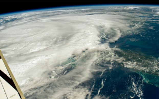
Astronauts on the International Space Station capture Hurricane Idalia on August 29, 2023. Courtesy of NASA
The storm tore into Florida as a high-end Category 3 hurricane with maximum sustained winds near 125 mph, splitting trees in half, ripping roofs off buildings and turning cars into boats with incredible storm surge.
It kept going too. After making landfall in Florida, Idalia remained a hurricane as it crossed into Georgia with top winds of 90 mph.
Cedar Key, Florida experienced a 7 foot storm surge, the largest measured from the hurricane. The town is located about 90 miles away from where Hurricane Idalia made landfall. It was the highest storm surge ever recorded for the town, breaking the old record set by Hurricane Hermine in Sept. 2016.
Why was this a difficult forecast?
So why was the initial forecast only forecasting a Category 1 storm? Forecasting rapid intensification is a very difficult thing to do.
Rapid intensification occurs when a tropical cyclone (whether a tropical storm or hurricane) intensifies by at least 35 mph in a 24-hour period. Usually, tropical storms, hurricanes, increase in intensity at a relatively steady rate.
Gabriel A. Vecchi, professor of geosciences at Princeton University in New Jersey, said in an interview with the Canadian Broadcast Company, “The probability of it (rapid intensification) happening now is considerably more and it’s been growing over the last 40 years.”
In the past, it was somewhat rare for storms to keep strengthening until landfall, let alone do so rapidly. Now it is not — and studies show this is a dangerous sign of climate change.
Why is rapid intensification happening so frequently?
As more greenhouse gases are released into the atmosphere from the burning of fossil fuels, the Earth’s temperature rises.
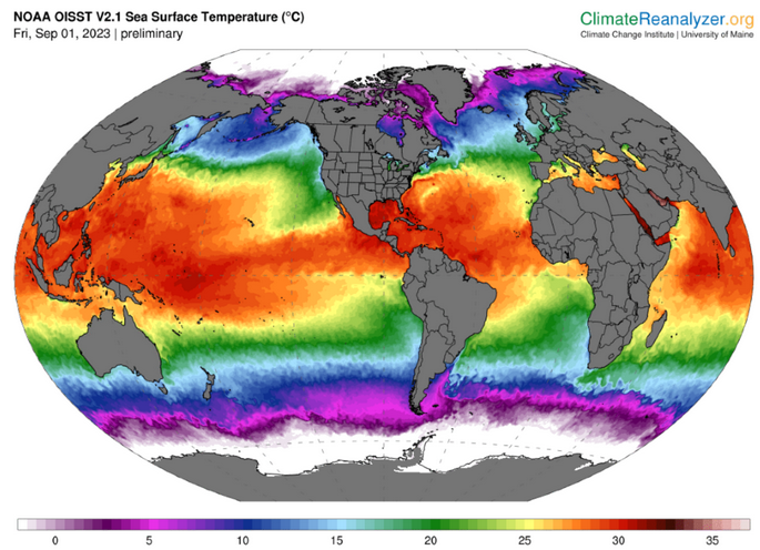
Most of the excess atmospheric heat is absorbed by the ocean. In fact, the world’s oceans absorb about 90 percent of it. As a result, sea surface temperature (SST) has increased significantly over the past few decades.
Globally, SSTs have risen to the warmest on record, and that warming extends to the Gulf of Mexico, where Hurricane Idalia formed.
Since hurricanes get their fuel mainly from warm ocean waters, it’s a significant concern among scientists and weather forecasters.
While it’s hard to attribute climate change to influencing any particular storm’s strength or behavior, there is strong evidence that a warmer climate is making these storms stronger and more dangerous.
NASA agrees
NASA says that since the 1980s, the hurricane record has shown a more active period in the North Atlantic Ocean. On average, there have been more storms, stronger hurricanes, and an increase in hurricanes that rapidly intensify. It’s important to note that NASA believes that most of these increases are from natural climate variations.
However, NASA goes on to say that one recent study suggests that the latest increase in the proportion of North Atlantic hurricanes undergoing rapid intensification is a bit too large to be explained by natural variability alone. This could be the beginning of detecting the impact of climate change on hurricanes.
While a warmer climate may not impact hurricane frequency, it may cause a greater proportion of the storms that form to reach very intense (Category 4 or 5) levels. In other words, while it may not cause a change in the number of storms that form, the ones that do have a greater chance of becoming stronger.
Rapid intensification forecasts improving
While rapid intensification is of deep concern, such as with Hurricane Idalia, forecasts are improving, which is saving lives. Florida experienced no deaths attributed to storm surge, the deadliest part of a hurricane.
While the initial NHC forecast didn’t call for a major hurricane to develop with Idalia, it wasn’t long before it did.
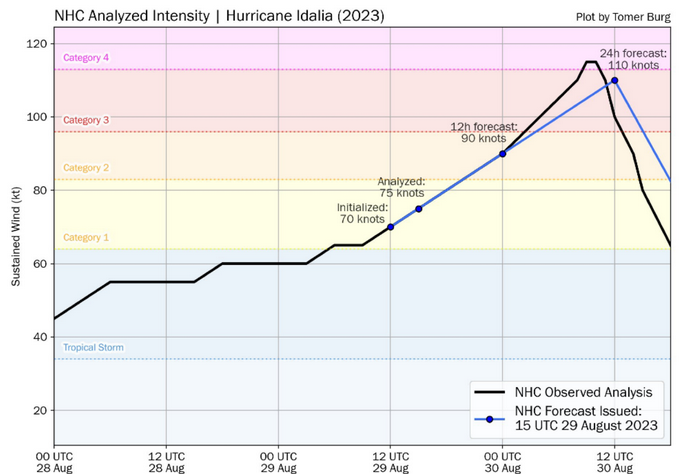
At about 3 days before landfall, the early forecast predicted Idalia to be a Category 1 storm at landfall along Florida’s Gulf Coast. At 5am ET on Sunday, August 27. However, during that forecast, National Hurricane Center (NHC) forecaster Eric Blake immediately voiced concern in the NHC’s technical discussion for meteorologists and emergency managers that rapid intensification was possible.
Blake wrote, “There’s a notable risk of rapid intensification while the system moves across the record warm eastern and northeastern Gulf of Mexico.” He added, ”The upward overnight model trend certainly bears watching.”
Blake noted that the current forecast of a Category 1 storm at landfall might be underestimated.
Credit: Tomer Burg via Twitter/X
Within 48 hours of landfall, the NHC’s forecast was brought in line with the eventual outcome of a land-falling major hurricane of Category 3 intensity.
That NHC forecast for the 24-hour intensity increase showed a 45-mph boost in maximum sustained winds, which tied for their highest such forecast on record.
Idalia’s winds actually increased by about 55 miles per hour in 24 hours, greatly exceeding the 35 mph increase needed to be categorized as experiencing rapid intensification.
While the extremely warm, Jacuzzi-like waters of the Gulf of Mexico prime storms for rapid intensification, forecasters at the NHC and the Climate Adaptation Center (CAC) are becoming more skilled at predicting how climate change is impacting each storm’s strength and development.
How the CAC saw Idalia before development
The Climate Adaptation Center is constantly monitoring how climate change is effecting our oceans around the world.
Our CEO, Bob Bunting, wrote in Sarasota Magazine days before the storm developed, that he expected a storm to organize. “The tropics have been on fire, with three new named topical storms and several more that look likely.” He added, “All of this heat is causing marine heat waves (MHW) and the potential path of this new tropical storm or hurricane means that it’s time to pay attention.”
Just two days later, Tropical Storm Idalia developed.
Bunting expected, at least, a Category 2 hurricane to develop and expressed his concern about the significant risk of a major hurricane.
The team at the CAC is committed to connecting the scientific community with the public sector and private enterprise to apply climate science to solving Florida’s unique challenges.
However, the CAC is a non-profit organization depends on financial support from our local community and from readers around the world. If you would like to support the CAC so it can ensure Florida’s future, you can do so here. We can’t do it without you.