Hurricane Ian Nears Category 5 Intensity
[Editor’s note: This article by CAC CEO Bob Bunting was released earlier in the CAC Newsletter of September 28, 2022. This article is updated as of 12:00 September 28th to provide the latest information on this rapidly developing situation. Sign up for the free CAC newsletter here.]
Hurricane Ian is moving mostly northward approaching the southwest coast of Florida. The Category 3 storm [now Category 4 – Ed.] went though a eye replacement cycle and the eye and the hurricane and gale force winds have expanded. It also resulted in the wobble of the eye eastward and that has changed the center of the strike area where the eye of Ian will cross the coastline. The latest National Hurricane Center forecast is shown below.
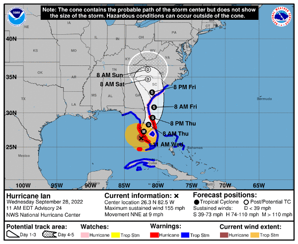
Because the coastline of southwest Florida bulges into the Gulf of Mexico south of Sarasota, it now looks like the eye will come ashore sooner, in the area from Venice to Port Charlotte on our Suncoast.
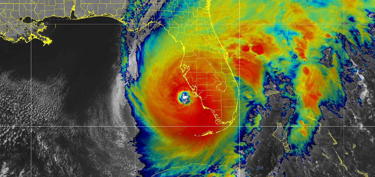
Color-enhanced satellite image captured at 11am EDT, as the eyewall of the hurricane approached the coast. Image source: CIRA/NOAA
[Editor’s note: The National Hurricane Center reports that as of noon EDT September 28th, the eyewall of Hurricane Ian is moving onshore at Sanibel and Captiva Islands. Maximum recorded winds of 155 mph. Ian’s rapid intensification has elevated the hurricane to near Category 5 levels.]
Peak winds will gust to well over 100 mph near the center as Hurricane Ian makes landfall with storm surges of 8 ft to 12 ft. We will see unbelievable impacts from this hit on the southwest coast.
Taken together all these changes do have some moderating impacts, especially to the north of Sarasota where wind and storm surge will be somewhat less intense sparing Tampa Bay from what we will see further south.
In the Sarasota Metro Area, including the barrier islands, the change means peak winds will be 10 to 20 mph less — maximum winds will peak in the 80 to 90 mph range.
Gales are already beginning and hurricane force winds will arrive late this afternoon and continue though early Thursday morning with gales continuing tomorrow during the day.
While storm surges will be less in the metro Sarasota area they will cause flooding issues. Any wobble of the eye of Ian to the north today will increase the storm surge for the metro area. Remember, these storms are dynamic and they bump along rather than traveling in straight lines.
The hazard from extremely heavy rains has increased and we may see 15 to 20 inches of rain with some spots with 2 feet of rain in a wide area north of the eye’s landfall! Extensive flooding will result.
The CAC 2023 Climate Conference titled “The Triple Threat From Water & The Emergence Of The Climate Economy” is scheduled for February 9th at the Selby Auditorium of the University of South Florida in Sarasota. This storm is the epitome of that threat! Conference details will be listed soon on the CAC website.
This is the time to listen very carefully to evacuation orders. Remember, the power grid will be damaged and electricity will go off and roads will quickly become dangerous to navigate.
Make intelligent science based decisions. Protect your property but be sure to protect yourself!
Good Luck Everyone!
The CAC is planning on continuing updates on the storm until it is gone. You may view these articles on the CAC website, Sarasota Magazine, or if you sign up for our CAC monthly newsletter using the “Subscribe” link below, you will automatically receive an email update in your mailbox as soon as it is posted.