Yesterday’s developing system is now a Tropical Storm
Tropical Storm Idalia Forms
The tropical system in the Caribbean Sea, south of Cuba, has become Tropical Storm Idalia. This is the 5th new tropical system in the past week or so, the 10th tropical storm of 2023 and the 94th tropical storm in the past 5 years!
A Hurricane Watch is now in effect for much of the west coast of Florida including Tampa Bay and all of the Sarasota Metro area.
Idalia is the latest in a burst of tropical storm activity that I have been warning about for the past few weeks. A potentially historic peak hurricane season is arriving.
This morning’s satellite image showed the low level center forming.
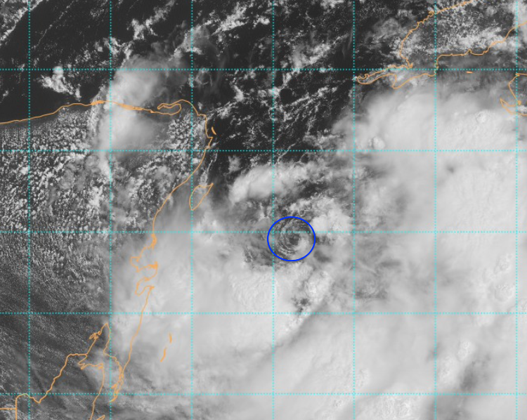
GOES-East image courtesy NOAA/NEDIS/STAR
Inside the blue circle, you can clearly see the storm’s center forming.
Next, is the water vapor image taken recently by the GOES Satellite.
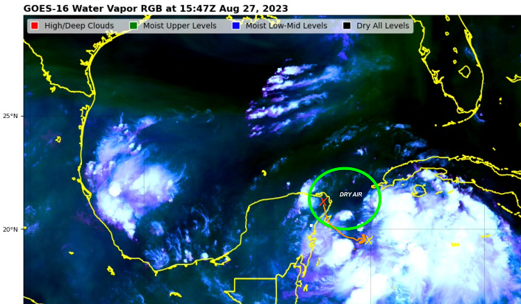
Dry air is slowing Idalia’s formation for the time being. Image courtesy NOAA/NESDIS/STAR
The area inside the green oval is mostly black which means the air is dry. That dry air is slowing formation for now.
The Storm Track Is Shifting
The orange “X” over Yucatan shows the spot where yesterday’s forecast projected it to be by today. The yellow X shows the actual location of the center now.
The storm track has shifted eastward—a bad sign for the west coast of Florida. Had the storm ejected into the Gulf of Mexico from the position yesterday, the northern Gulf states would have been the target.
However, this eastward drift means the storm could enter the Gulf from western Cuba… the worst possible location for Florida threats!
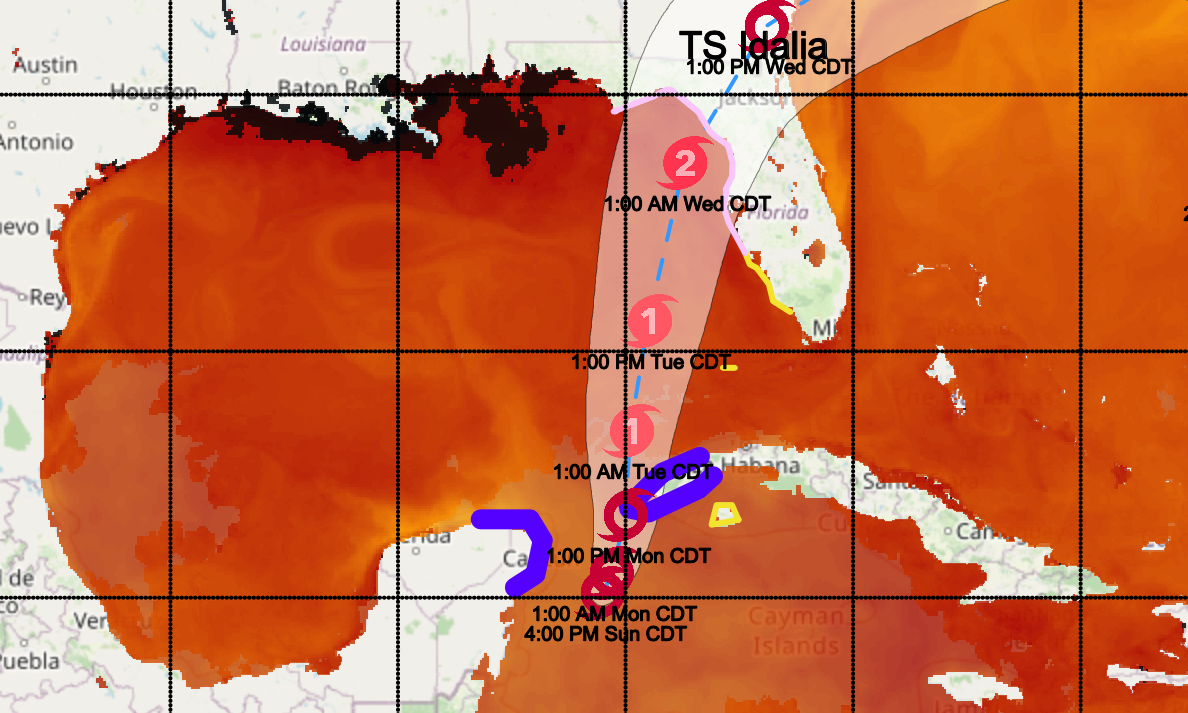
To be consistent with our previous post, here is the SST and path outline updated.
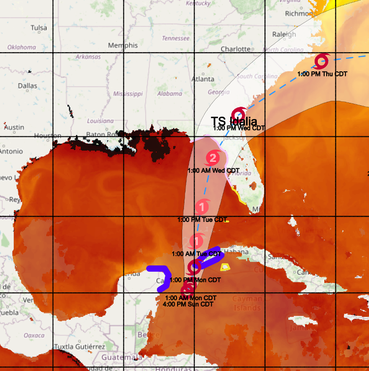
Projected track of Tropical Storm Idalia. Very warm SSTs in the eastern Gulf of Mexico will energize the storm.
Idelia, with a center forming, is expected to brush Cuba’s western province. Tropical Storm Warnings are in effect for the coastal areas shown in blue. Yellow zones are under Tropical Storm Watch.
Idalia should be drifting slowly for at least another day. As it continues forming, details will change, helping to crystallize the likely Florida impact.
The pale cone-shaped area on the map represents the probable track of the center of the storm going forward. The eye of the storm is projected to be within this cone at the time stated. The dashed center line is not important now.
Notice how the warnings in blue and watches in yellow are mostly outside the cone. That’s because the storm impacts extend far beyond the path of the eye of the storm.
Wind shear in the upper atmosphere above the storm is light, which means Idalia will likely enter the Gulf as a Category 1 storm.
Idalia Will Strengthen Over the Gulf
The red areas in the graphic above represent sea surfaces temperatures above 86°F. The exceptional heat in the Gulf of Mexico will feed the storm the energy it needs to grow.
Although the storm right now is expected to become a Category 2 as I suggested yesterday, there is considerable risk it could become a Major Hurricane before it crosses the Florida coast.
The current path of the storm’s eye is within striking distance of Tampa and/or Sarasota.
DO NOT Let your guard down. The forecast path will change somewhat depending on how its structure evolves.
Right now, it looks like the northeast and southeast quadrant of the storm will be most severe. Again, this will mean serious impact potential.
The Supermoon is full on August 30th! That means tides will be that much higher as the storm moves up the west coast, even if it’s offshore!
A final point. Even without a Supermoon, a Category 2 storm today has much higher surges and tides because sea level is 9 inches higher than it was in 1950. That is a lot!
The Supermoon, 9 inches of sea level rise, and record warm sea surface temperatures all combine to increase the threat. The Climate Has Already Changed!
Since the Suncoast is in the potential path, Please think about: What is your elevation? Where will you go if evacuations become necessary? Will you move your autos to higher ground? Do you have your important papers packed so you can take them with you? Are you prepared for long-lasting power outages?
Remember the CAC had a nearly perfect long range and short range forecast of Hurricane Ian.
IRMA, IAN AND IDELIA….NEED I SAY MORE.
Make intelligent, science-based decisions. Protect your property, but be sure to protect yourself!
The CAC is planning on continuing updates until the storm is gone. You may view these articles on the CAC website or at Sarasota Magazine. If you subscribe to the CAC monthly newsletter with the “Subscribe” button below, you will automatically receive an email update in your mailbox as soon as it is posted.
Now is a good time to:
- Consider if you are in a low-lying area and could face high tides and storm surge
- Figure out where you will go if you need to evacuate
- Stock up on water, batteries and essentials now while you have time
- Above all get prepared and watch what is going on in the tropics
Remember:
- Sea levels are already nine inches higher than they were 50 years ago so even minor storms have bigger flooding impacts
- Escape routes can be very vulnerable because roads in many areas have not been raised far enough above sea level
- Power can be off for days in some areas depending on the severity of winds and surge. Consider this in your planning.