Title image courtesy European Union, Copernicus Sentinel-2 Imagery
1.5ºC or 2ºC – Will It Make a Difference?
In the past year, we published articles about a number of extreme weather and climate events affected by climate warming, ranging from our 2021 and 2022 Atlantic hurricane forecasts to a review of the southwestern U.S. megadrought. In his article about the extreme heat and raging wildfires in western North America in the summer of 2021, Dr. Corell points out that those events were driven to exceptional extremes by climate change. Presumably things will get even worse if the climate continues to warm, but how much worse? Will an extra half a degree of warming really matter? (Spoiler alert: yes, it will)
How Much Warming Should We Plan For?
In the months following COP26 in Glasgow, and nations’ promises to rein in climate warming, we’ve seen much speculation on how much future warming we can expect. Can we limit warming to 1.5ºC above pre-industrial levels? 2ºC? 2.7ºC? Answering this question is critical to assessing likely future risks of extreme weather and climate events.
In the Paris Agreement, the 1.5ºC target was selected to minimize the chances of irreversible changes to climate and ecosystems. Unfortunately, global average temperature is already 1.2ºC above preindustrial levels. The way things are going, in the next five or six years the accumulation of greenhouse gases in the atmosphere will likely reach the amount that will push the global temperature average above 1.5ºC. Although we know how to achieve the 1.5ºC goal, and we have all the technology and resources to do it, the necessary political commitment is missing. Next stop, 2ºC…
In early April 2022, an analysis of the results of COP26 by Meinshausen et al determined that if all national pledges and commitments were carried out in full, and on schedule, we may be able to limit total warming this century to “just below” 2ºC.
Unfortunately, shortly thereafter the war in Ukraine upended the global energy market — to the benefit of the fossil fuel industry and to the detriment of national efforts to reduce greenhouse gas emissions. Even without that speed bump, the analysts at Climate Action Tracker point out that if you weed out all of the COP2 arm waving and grandstanding, and run the numbers based only on firm commitments, “government current policies will put warming at 2.7ºC.”
COP27 will convene in Sharm el-Sheikh, Egypt in November. It will be interesting to see how much progress has been made post-Glasgow.
Extreme Weather Events Are Already Responding to Climate Warming
At today’s 1.2ºC of warming it is no longer a question of if climate warming is affecting extreme weather, but how much?
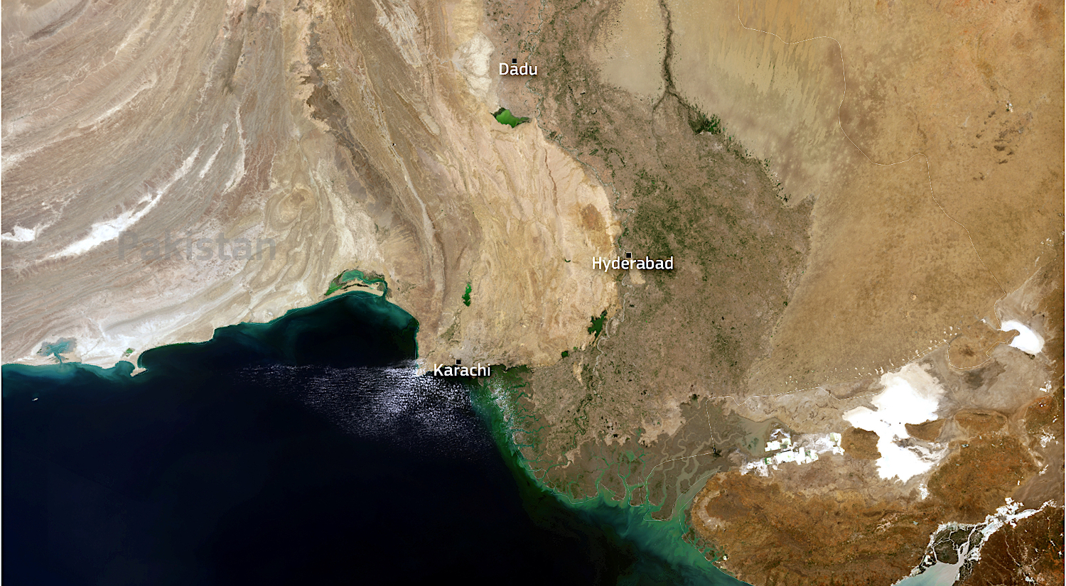
As we were working on this article, the annual hot season in India and Pakistan was setting new temperature records. India recorded its hottest March in 120 years of record keeping, and the heat wave continued into April, with temperatures 4.5 to 8.5°C (8 to 15°F) above normal in east, central, and northwest India. On April 29th, 2022, the India Meteorological Department reported that 32 cities suffered temperatures of 45ºC (113ºF) or more.
It would get worse. On April 30th the temperature reached 49.0ºC (120.2°F) at Jacobabad, Pakistan.
The NASA image below highlights the broad extent of the record-setting heat wave.
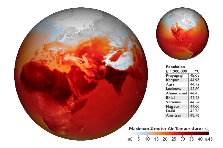
April 27, 2022 air temperature map. Image: NASA
The knock-on effects of the extreme heat include heat-related health issues, crop damage, a surge in wildfires, and deteriorating air quality. At the same time, the unanticipated surge in energy demand led to a major electricity shortage in India.
While South Asia baked in an extreme heat wave, the southeast coast of South Africa experienced an extreme precipitation event, inundated with nearly an entire year’s rainfall in just 48 hours over the Easter weekend. This extreme rainfall event followed hot on the heels of the disastrous 2022 Southwest Indian Ocean cyclone season we reviewed earlier. The resulting floods destroyed houses, bridges, rail lines and roads, killing 435 people and leaving thousands homeless.
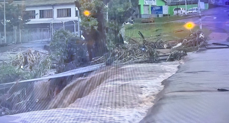
April 2022 heavy precipiation event, South Africa. Image Credit: Hindou Oumarou Ibrahim via Twitter
So, how much worse will it get? After all, 2ºC is only another eight-tenths of a degree warmer than today.
The Future of Extreme Weather
The Intergovernmental Panel on Climate Change (IPCC) has answers.
Created in 1988, the IPCC is regarded by scientists and governments as the world’s premier authority on climate change. The IPCC performs periodic, systematic reviews of all published literature and data sets relevant to climate change, aided by thousands of scientists and subject matter experts. A critical function of the IPCC is the periodic publication of “Assessment Reports” — comprehensive reviews of the state of global climate change for policymakers and the public at large. In 2015, the IPCC’s Fifth Assessment Report (AR5) was the scientific foundation for the Paris Agreement. The subsequent Sixth Assessment cycle will culminate in the publication of AR6 in the lead-up to COP27 in Sharm el-Sheikh, Egypt, in November 2022. AR6 comprises four working group reports, three of which have been released in draft form:
- The Physical Science Basis (Working Group I, August 2021)
- Impacts, Adaptation and Vulnerability (Working Group II, February 2022)
- Mitigation of Climate Change (Working Group III, April 2022)
- Synthesis Report
The disturbing findings of the Working Group I report were a major impetus for nations’ more aggressive GHG commitments at COP26 in November 2021.
Getting less attention in the AR6 draft is the Working Group I analysis [pdf] of the effects of climate warming on extreme weather. However, record-setting weather events around the world in the last few years show that the impacts of climate warming can be far greater than a few tenths of a degree on the thermometer. Buried within the AR6 report’s thousands of pages are these unequivocal statements:
It is an established fact that human-induced greenhouse gas emissions have led to an increased frequency and/or intensity of some weather and climate extremes since pre-industrial time, in particular for temperature extremes.
…even relatively small incremental increases in global warming (+0.5°C) cause statistically significant changes in extremes
To put it simply, every tenth of a degree matters. AR6 draws on new sources of data, improved climate models and the continued refinement of weather-related event attribution science to forecast the impact of continued climate warming on extreme weather events ranging from heat waves to tropical cyclones. As adaptation to inevitable change becomes imperative, it’s time to assess what 2°C (or more) means for scope of potential adaptation strategies capable of protecting against extreme weather events.
Temperature Extremes
Although we talk about global warming in terms of changes in the global annual average temperature, this can be misleading — land areas warm faster than oceans, for example. As a result, regional warming on land is generally more than 1.5°C even when mean global warming is at 1.5°C.
AR6 predicts that further increases in the intensity and frequency of hot extremes and decreases in the intensity and frequency of cold extremes will occur throughout this century and around the world. The number of hot days and hot nights and the length, frequency, and/or intensity of heat waves will increase over most land areas. Similarly, we will see decreased intensity and frequency of cold days and nights and a decrease in the duration of cold spells.
In most regions, future changes in the intensity of temperature extremes will very likely be proportional to changes in global warming, but up to 2–3 times larger. Comparing global warming of 1.5ºC to 2ºC, a difference of only 0.5ºC, we can expect an increase of 1ºC to 1.5ºC in some regions.
Particularly large increases in the intensity and frequency of hot extremes are predicted for many densely inhabited regions. The greatest temperature increases for the most extreme hot days are expected to occur in central and eastern North America, central and southern Europe, the Mediterranean, western and central Asia, and southern Africa.
For warming of mean temperature and cold extremes, the strongest warming is found in the high-latitude regions of the northern hemisphere, related to the “polar amplification” process. The coldest nights in high latitudes warm by as much as 1.5°C for every 0.5°C increase in the global average.
The annual total number of hot days shows the largest differences between 1.5°C and 2°C in the tropics, where temperatures vary the least throughout the year. As a result, extreme heatwaves are predicted to appear earliest in the tropics, becoming widespread at 1.5°C of global warming. AR6 suggests that limiting global warming to 1.5°C instead of 2°C could result in around 420 million fewer people being frequently exposed to extreme heatwaves.
From a global point of view, a 2018 paper predicted that in a 1.5°C world, about 14% of the world population will be exposed to severe heat waves on average once every 5 years. Under 2°C warming, nearly 3 times as many people (37%) would be affected — a difference of around 1.7 billion people.
Heavy Precipitation Events
Observations and predictions are less reliable for precipitation than for temperature. However, global observations over time show that most areas are showing an increase in the frequency, intensity and/or amount of heavy precipitation. At global scale, the increasing intensity and frequency of heavy precipitation events parallels the increase in the maximum amount of water the atmosphere can hold as it warms — roughly a 7% increase for every degree of global warming. More difficult to predict are other changes related to regional-scale warming, changes in atmospheric circulation, or storm dynamics.
We should expect a global increase in heavy precipitation over land at 2ºC compared to 1.5ºC. Regions predicted to show significant changes in heavy precipitation between 1.5ºC and 2ºC global warming are located in higher latitudes (Alaska/western Canada, eastern Canada/Greenland/Iceland, northern Europe, and northern Asia), high elevation (the Tibetan Plateau, for example), eastern Asia and eastern North America.
This isn’t news in some areas. The image below shows the results of a May 2022 heavy precipitation event in southern and southeastern Manitoba, Canada. In the month of April, rainfall in the area ranged from 4oo to 600% of normal!
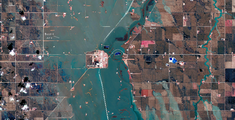
May 5, 2022 flooding in Manitoba, Canada caused by an extreme precipitation event. Image: European Union, Copernicus Sentinel-3 Imagery
The increased intensity of extreme precipitation with global warming will result in an increase in the frequency and magnitude of surface water flooding and flash floods. Unlike river flooding, these flood types simply result from precipitation intensity exceeding the capacity of natural and artificial drainage systems. In the case of the Manitoba flood, the seasonal snowmelt runoff in the Red River basin was compounded by the heavy precipitation event.
River Flooding
In general, global hydrological models project that more land areas in a warming world will experience an increase in river floods than experience a decrease. Increased river flooding is particularly likely to occur in the western Amazon, the Andes, and southeastern and northern Asia.
Significant trends in peak streamflow have been observed already in some regions, including increases in the Russian Arctic, parts of South America, northern Europe, and eastern North America and decreases in southern Australia, parts of the Mediterannean basin and east Asia. River flooding due to rapid snowmelt is happening earlier in the season as the climate warms.
Regional changes in river floods are more difficult to predict than changes in surface flooding because of complicating factors such as land cover change and human water management.
Extreme Storms
For our purposes, extreme storms include Tropical Cyclones/Hurricanes, Extra-Tropical Cyclones and Convective Storms (particularly tornadoes.)
Tropical Cyclones/Hurricanes
Regular readers of CAC’s frequent hurricane articles will be well aware of the changes in North Atlantic hurricane behavior caused or amplified by climate warming. Of course, tropical cyclones are a global phenomenon and a threat to coastal areas around the world. As we approach 1.5°C of warming and potentially 2°C, it is worth considering the potential impact of the extra half a degree of warming.
The IPCC’s Sixth Assessment Report concludes that “it is very likely that the recent active [Tropical Cyclone] seasons in the North Atlantic, the North Pacific, and Arabian basins cannot be explained without an anthropogenic influence.” In other words, our input to global warming is now driving the evolution of the world’s most extreme storms.
The key findings of AR6:
- worldwide, there may actually be slightly fewer tropical cyclones at 2ºC of climate warming than at 1.5ºC, but…
- average peak wind speeds and the proportion of intense hurricanes (categories 4-5) is likely to increase
- tropical cyclones in the North Pacific will migrate northward as the warming tropics expand
- heavier precipitation will be associated with tropical cyclones/hurricanes at 2°C compared to 1.5°C of warming
As with the evolution of heavy precipitation events described earlier, tropical cyclone precipitation will rise with local warming at least at the rate of water vapour increase over oceans (roughly 7% per degree of warming). However, hurricanes can exceed this rate in cases where intense wind drives increased low-level moisture convergence for rainfall generation.
It is possible that the global number of tropical cyclones will be the same or lower at 2°C of global warming compared to less than 1.5°C of warming, while the number of very intense cyclones may increase. Overall, we anticipate heavier precipitation associated with tropical cyclones/hurricanes at 2°C compared to 1.5°C of warming.
As we know, much of the damage caused by hurricanes is due to extreme rainfall and flooding, and climate warming is unequivocally increasing tropical cyclone precipitation. The poster child for this phenomenon is Hurricane Harvey in 2017. Also linked to climate warming is the relatively recent tendency of North Atlantic hurricanes to move very slowly as they pass over the continental U.S. — amplifying the impact of the already heavy rainfall.
Extra-Tropical Cyclones
Extra-Tropical Cyclones are simply the familiar mid-latitude low pressure weather systems that march across the U.S. year-round. The current science suggests that the intensity of these storms is unlikely to change much with global warming. However, the link between climate warming and increasing moisture in the atmosphere means that average and peak precipitation rates will increase.
Climate warming is also likely to shift storm tracks in some regions, exposing some areas to unfamiliar levels of storm activity.
Convective Storms (tornadoes etc)
Severe convective storms (e.g., thunderstorms and tornadoes) can cause localized loss of life and extensive property damage. Tornadoes in particular are so localized that there isn’t a coherent global database to use as the basis for climate warming impact projections. However, tornado records in the U.S. are sufficient to show trends in the context of climate warming. It appears that the annual number of tornadoes has remained relatively constant, but the pattern in which they occur has changed over the last 50 years. Particularly in the last 20 years, tornadoes occurred on fewer days per year, but with an increase in the number of tornadoes on those days.
Convective storms in general will respond to climate warming in much the same way as cyclones. For example, the average and maximum rain rates of severe convective storms is likely to increase in the U.S. and some other regions. Climate models suggest that continued warming in the tropics and subtropics will give rise to more severe convective storms, but sparse observations make it difficult to confirm the model results.
Droughts
We covered the complex cause and effect relationships for different types, causes and durations of drought and their relationship to climate warming in our recent post on the megadrought in the U.S. Southwest. The IPCC’s AR6 adds a global context for the future of droughts under global climate warming.
As you might expect, the likelihood of increasing dryness and reduced water availability in drought-prone regions will increase in lock-step with increased climate warming. Globally, AR6 suggests that the consequences outside North America will be most dramatic in regions already on the verge of a serious water deficit, specifically the Mediterranean region (southern Europe, northern Africa and the Near East) and southern Africa. In particular, the change from 1.5ºC of warming to 2ºC may be the tipping point for the Mediterranean region.
A Last Word…
There is a growing mountain of evidence and reputable predictions confirming that, indeed, “every tenth of a degree matters.”
For confirmation, we need look no further than the extreme events in India, Pakistan, South Africa and Canada that happened even as this article was being written.