Global Climate Chaos
“Everything, Everywhere, All at Once” is not only the title of an Oscar-winning film, but also an apt description of the tumultuous state of the global climate in the summer of 2023.
There’s an El Niño in Our Future
In Part 1 of our recent two part post on the 2023 weather outlook, we considered the possibility of an El Niño climate pattern developing later in the year. By mid-May, the cooling effects of last year’s “triple dip” La Niña had given way to a steadily warming climate. The World Meteorological Organization (WMO) predicted that warming oceans would lead to warmer than usual weather by June, July and August. In fact, March and April saw near-record daily temperatures over land and in the oceans. Unusually for this time of year, heatwaves struck China, western Europe, and Northwest Africa. In North America, a heatwave developed in the Pacific Northwest and a persistent heat dome in northern Canada led to an unprecedented wildfire outbreak. Remember, El Niño hadn’t begun at this point…
By the time we published Part 2 in mid-June, rapid and extreme changes in the weather removed any doubt that a full-fledged El Niño was developing. Global temperatures were well above average, reaching record levels in early June. A heat dome brought blistering heat to Texas and Mexico, while wildfires fueled by hot, dry weather consumed millions of acres in the forests of northern Canada, pouring dense smoke into the northeastern US and as far east as Europe. Oceans set daily global average sea surface temperature (SST) records, pumping more heat and moisture into the atmosphere.
At this point, there was no doubt that an El Niño will develop over the coming winter. Although the full impact of El Niño won’t be realized until 2024, nonetheless 2023 was widely predicted to be one of the five warmest years on record. (The warmest year was 2016, another El Niño year.)
Here we are, just three weeks after wrapping up our 2023 weather outlook and stuff has well and truly hit the fan…
(Editor’s note: In the rest of this post we do our best to keep up with fast-changing information. Some data sources may predate others by a few days. Others may be overtaken by events.)
Dramatic Changes in the Oceans
Decades of climate warming driven by human emissions of greenhouse gases have pumped enormous amounts of heat energy into the earth system. Fully 89% of that heat energy is absorbed by the oceans. Although the oceans have been inexorably warming as a result, the trend was obscured over the last few years by the cooling effects of a persistent La Niña. Now the situation is reversed. Not only is the warming trend no longer being suppressed, but also we are seeing the amplifying effect of the developing El Niño. Record global ocean temperatures are the result.
The following chart shows the daily sea surface temperatures averaged over all the world’s oceans, excluding the arctic and antarctic. The orange line shows the data from 2022. The black line illustrates the jump to 2023. (Note that the daily data record began in 1981. The 1982-2011 average is represented by the small dotted line.)
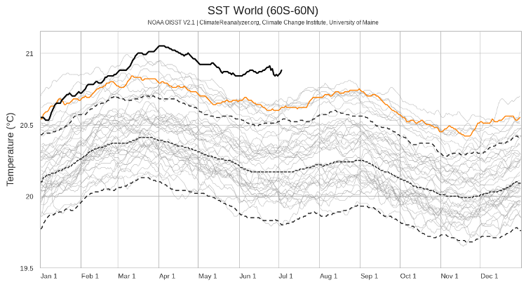
Credit: Climate Change Institute, University of Maine
The change is particularly dramatic in the North Atlantic Ocean, as shown in the graph below.
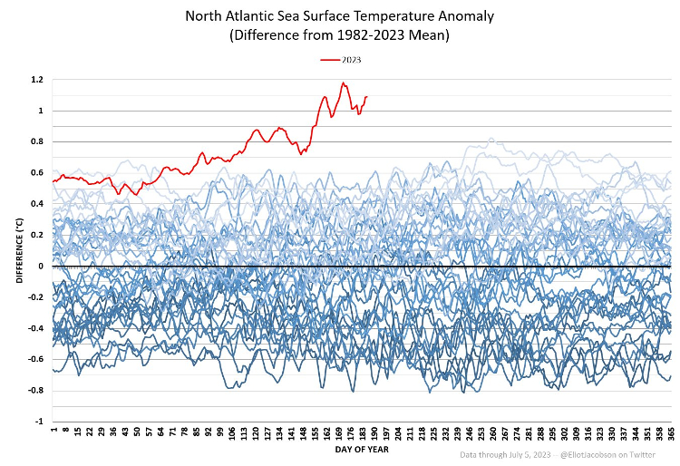
Credit: Eliot Jacobson / @EliotJacobson (Twitter)
The graph shows daily SST anomalies—the difference between daily measurements and the 1982-2023 mean for each day (the black line.) If a daily value is the same as the average for that day of the year, the anomaly is zero. Positive anomalies indicate warmer than average conditions. The red line shows that 2023 is truly “off the charts.”
One result has been an extreme marine heatwave around the UK and Ireland, shown in the image below. Like hurricanes, the severity of marine heatwaves is indicated by categories ranging from 1 through 5. At its most intense, this heatwave was a “Cat 5,” with sea surface temperatures 4-6ºC above average.
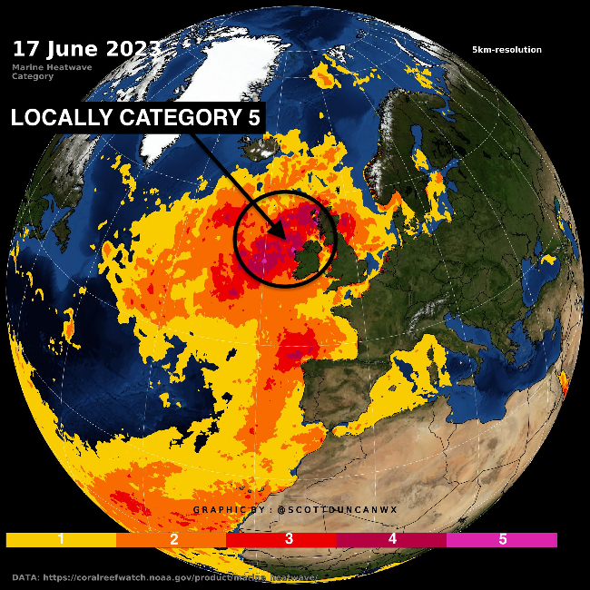
Credit: Scott Duncan / @ScottDuncanWx (Twitter)
This extraordinary heatwave has lasted for more than two months and may continue for the rest of the year.
Disappearing Sea Ice
You would expect sea ice to diminish in warming oceans. While reality is more complex than that, the global extent of sea ice reached record lows in 2023, as shown in the graphic below.
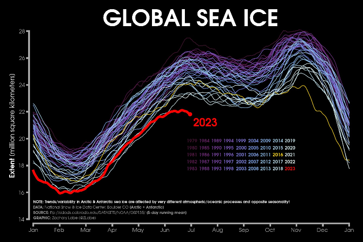
Credit: Zachary Labe / @ZLabe (Twitter)
The low levels in June and July are especially unexpected, given that ice should be accumulating during the Antarctic winter.
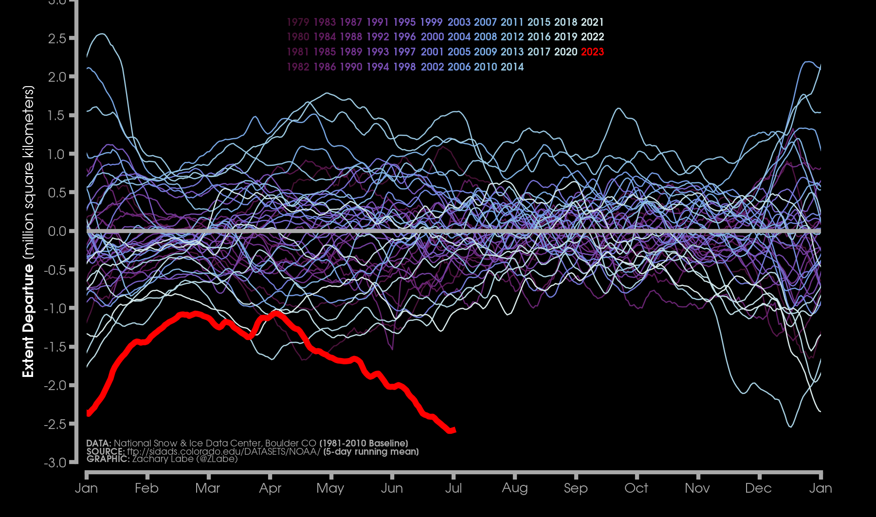
Arctic sea ice has been dwindling for decades, and the trend has been accelerating since 2000. The graph below suggests that the summer of 2023 may reach record levels—not surprising given the high temperatures in the North Atlantic. (Note that the graph shows anomalies—sea ice extent relative to the 1981-2010 average for the given day.)
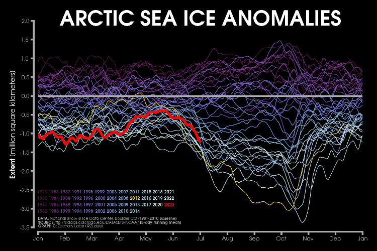
Credit: Zachary Labe / @ZLabe (Twitter)
Research published in June, 2023,s projects that at the current rate of decline, we may see the first ice-free Arctic summer in history within the next two decades, regardless of how rapidly we reduce greenhouse gas emissions.
The situation is even more dramatic in the Antarctic. Sea ice surrounding the continent protects the Antarctic ice sheet and coastal ice shelves (extensions of the ice sheet over coastal waters) from the warmer ocean. As we can see in the graph below, the protective ring of sea ice is declining at record rates in 2023, even as we enter the Antarctic winter. In an earlier post, we discuss how exposing the ice sheet to warm ocean water and warming air could lead to deterioration of the ice sheet and ultimately to dramatic global sea level rise.
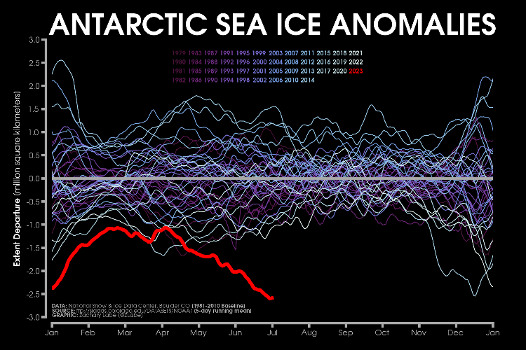
Credit: Zachary Labe / @ZLabe (Twitter)
Unprecedented Heat Worldwide
That hot weather you’ve been experiencing the last couple of months? As shown in the graph below, this year is unprecedented. On July 7th, Zeke Hausfather of Berkeley Earth pointed out that the four warmest days ever were July 3rd, 4th, 5th and 6th, 2023. As I write, Thursday July 6th now holds the record, at 17.23 ºC, but perhaps not for long. (The relatively unimpressive record temperature reflects measurements averaged over the entire earth’s surface, including the oceans.)
Given that global temperature typically peaks in late July, and that El Niño is still developing, we may break the daily record again this year.
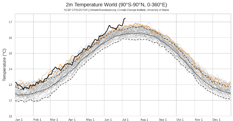
Credit: Climate Change Institute, University of Maine
On a monthly basis, we just experienced the warmest month of June on record, and judging by the chart above we’re well on the way to a record July.
Remember way back in May, when it looked like 2023 the third warmest year on record? Zeke Hausfather (Berkeley Earth) suggests that, given the June record, “2023 as a whole is now the odds-on favorite to be the warmest year on record in the ERA5 dataset at around 1.37ºC above pre-industrial levels.”
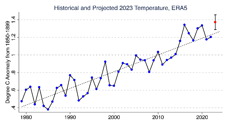
Credit: Zeke Hausfather / @hausfath (Twitter)
Atmospheric warming due to unrelenting greenhouse gas emissions, record ocean temperatures and a developing El Niño are combining to spawn dangerous heatwaves around the world:
- the Texas/Mexico heatwave broke records in numerous cities in both countries before the heat dome moved eastward toward Florida and the Gulf states. In some parts of Texas, the heat index reached up to 117ºF.
- China’s heatwave continues, setting an all-time record for the number of days over 95ºF in a six-month period. In late June, Beijing recorded three consecutive days above 40ºC (104ºF) for the first time since 1951, when its weather station started records. Chinese weather forecasters are issuing heat advisories for northern China, anticipating temperatures over 40ºC (104ºF).
- The UK Met Office reported that the UK had the hottest June since records began in 1884.
- The far-northern Canadian town of Kuujjuaq, Quebec set an all-time high temperature of 34ºC, highlighting the hot, dry weather that led to mammoth wildfires in Canada’s boreal forest. Hannah Ritchie, Head of Research at Our World in Data reports that about 8.5 million hectares (21 million acres) burned in the first half of 2023, more than the annual total for any other year since reliable record-keeping began in the 1960s
- Between mid-June and early July, Miami set eight high heat index records, the most recent at 107.4°F
North Africa and the Middle East have been particularly hard hit, as temperatures approach 50°C (122°F). Saudi officials reported more than 2,000 people were treated for heat stress during the hajj pilgrimage. The city of Sidi Slimane set an all-time June heat record for Morocco of 48.5C (119F). The striking image below brings home the point that heat records reported for isolated locations often indicate similar extremes over a very wide area.
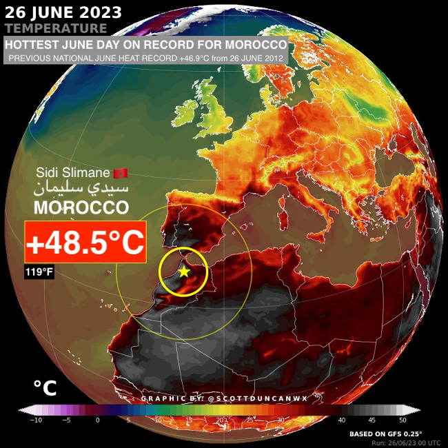
Credit: Scott Duncan / @ScottDuncanWx (Twitter)
What About Atlantic Hurricane Season?
As we mention in CAC hurricane forecasts, warm ocean water is rocket fuel for hurricanes. Warm water generates warm, moist air that carries heat energy up into the atmosphere. That heat energy supercharges atmospheric winds in the nascent hurricane.
So… record temperatures in the Atlantic should lead to a busy 2023 hurricane season, right? Well, not so fast.
Hurricane development also depends on vertically stable winds—winds that don’t change direction with height, a phenomenon known as wind shear. Wind shear disrupts hurricane formation. As we point out in the CAC 2023 Hurricane Forecast, atmospheric circulation associated with El Niño typically results in significant wind shear in the Atlantic basin.
So… at this point, we don’t know what’s going to happen.
We have already seen two named storms in the Atlantic in June, Bret and Cindy. That’s unusually early in the year, suggesting that exceptionally warm water may have the upper hand, if only temporarily. El Niño typically peaks in the November-February time frame. If this year’s El Niño ramps up earlier, it may put a damper on hurricane development.
What we do know is that there is more than enough heat energy in the North Atlantic to power a dangerous hurricane season. Even if El Niño hinders hurricane formation, there will be hurricanes in 2023.
Are We Nearing Climate System Tipping Points?
Tipping points in the climate system are critical thresholds. Crossing a threshold leads to large and possibly irreversible changes in the system.
Does all the 2023 chaos mean we’re reaching one or more climate tipping points? Probably not.
After all, so far we’ve only seen six months of the climate adjusting to an inevitable El Niñ0 event, following three years under the cooling effect of a La Niña. The warming effect of El Niñ0, coupled with persistent anthropogenic climate warming and continued high levels of greenhouse gas emissions, is likely making the transition from the La Niña regime more dramatic than we would normally expect.
COP28, the 2023 UN Climate Change conference is coming up later this year. Perhaps climate chaos is the wake-up call that will finally lead to meaningful international actions to deal with greenhouse gas emissions.
Perhaps.